Satellites are key to monitoring the state of forests around the world (e.g. see posts here and here). The company Planet has over 175 small satellites in orbit that are observing the earth and imaging the entire surface of the world every day, including views of every forest there is. In recognition of International Day of Forests back on March 21st, Planet released a video showing 7000 thumbnail images of forests around the world taken in a single day: Capturing the World’s Forests Over a Single Day – Planet Stories – Medium
https://vimeo.com/260994628
From the Planet item:
Pretty wild, right? Now what if we told you the video contains only a fraction of the total number of forest imagery Planet collects in a day — in this case, around 95,000 images. Planet collects a massive amount of data each day and has around 500 images for any given location on Earth. To extract “forests” from this data, we used an algorithm built to detect forest cover, dense green imagery, and high near-infrared averages.
To help people actually “see the forests for the trees,” we then applied more filters to those 95,000 images so those with lots of cloud cover or with visible defects were removed. (Fun fact: it would take around 30 minutes to watch all 95,000 images at 5 images per second — not exactly optimized for social.) Afterward, we organized imagery by continent and built an animation to showcase the scale and diversity of forests globally.
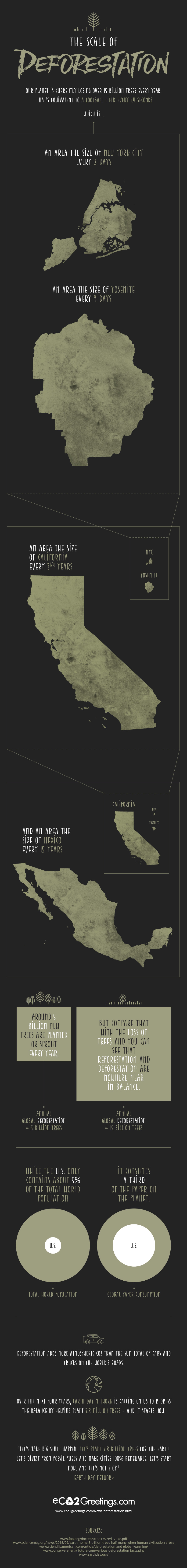
Such imagery is interesting but can also generated real data on the major problem of deforestation:
Of course, forests are not always untouched, pristine places, but dynamic environments that change dramatically with human interaction. Sadly, the world loses an area of forest the size of 48 football fields every minute due to deforestation and forest degradation.
Here is an infographic sent to me by a reader illustrating that high rate of the loss of forests around the world: The Scale of Deforestation – Eco2 Greetings
====