Category Archives: Gas giants Saturn, Jupiter, et al

Space science roundup – Feb.21.2019

A sampling of recent articles, videos, and images related to space related sciences:

** Mars weather reportsDaily Mars weather reports are now available from the Insight lander, which has activated its temperature and wind sensors – InSight Is the Newest Mars Weather Service | NASA

This public tool includes stats on temperature, wind and air pressure recorded by InSight. Sunday’s weather was typical for the lander’s location during late northern winter: a high of 2 degrees Fahrenheit (-17 degrees Celsius) and low of -138 degrees Fahrenheit (-95 degrees Celsius), with a top wind speed of 37.8 mph (16.9 m/s) in a southwest direction. The tool was developed by NASA’s Jet Propulsion Laboratory in Pasadena, California, with partners at Cornell University and Spain’s Centro de Astrobiología. JPL leads the InSight mission.

The white east- and west-facing booms — called Temperature and Wind for InSight, or TWINS — on the deck of NASA’s InSight lander belong to its suite of weather sensors. Credits: NASA/JPL-Caltech. Full image and caption

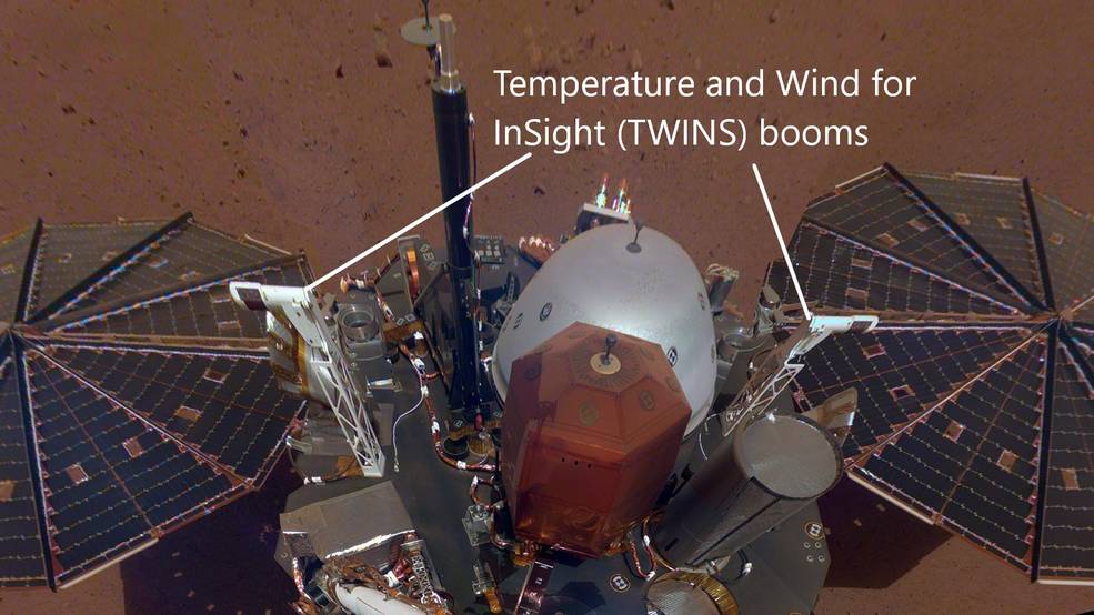
Through a package of sensors called the Auxiliary Payload Subsystem (APSS), InSight will provide more around-the-clock weather information than any previous mission to the Martian surface. The lander records this data during each second of every sol (a Martian day) and sends it to Earth on a daily basis. The spacecraft is designed to continue that operation for at least the next two Earth years, allowing it to study seasonal changes as well.

The tool will be geeky fun for meteorologists while offering everyone who uses it a chance to be transported to another planet.

Today’s readings:

A similar weather report is available from the Curiosity rover: Rover Environmental Monitoring Station (REMS) – Mars Science Laboratory.

The Mars Reconnaissance Orbiter (MRO) provides a view of global Martian atmosphere conditions: MRO MARCI Weather Report – Malin Space Science Systems.

** The Mars 2020 rover is coming together at NASA JPL in preparation for launch next year:

Tour the Spacecraft Assembly Facility at NASA’s Jet Propulsion Laboratory and see the Mars 2020 mission under construction. Project System Engineer Jennifer Trosper explains the hardware being built and tested, including the rover, descent stage, cruise stage, back shell and heat shield. This NASA mission is preparing to launch to the Red Planet in 2020 and land in 2012. For more about Mars 2020, visit https://mars.nasa.gov/m2020

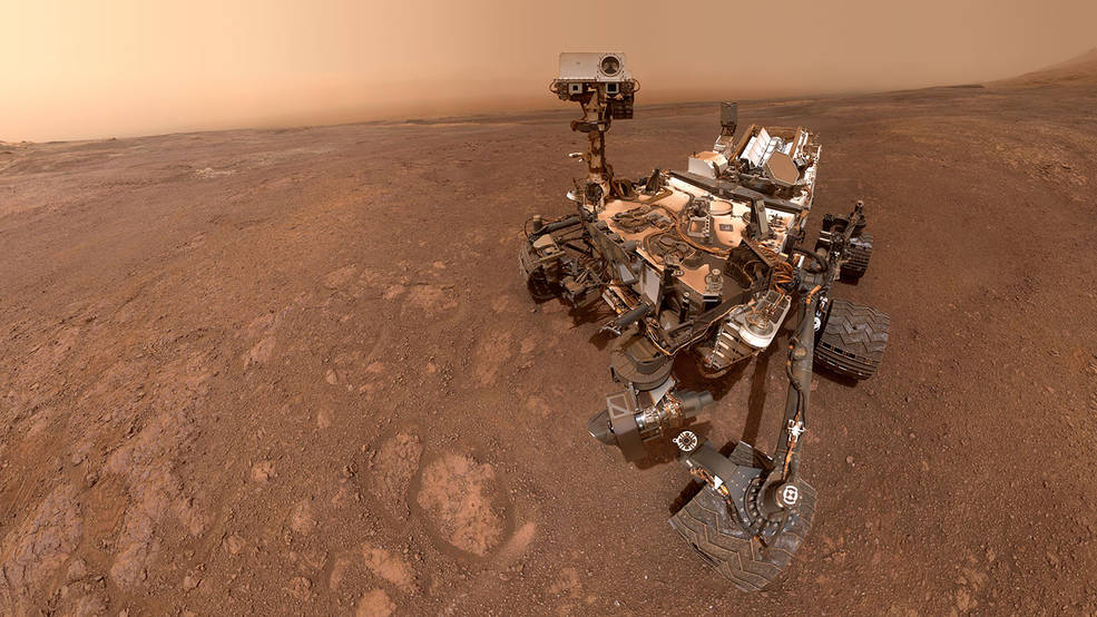
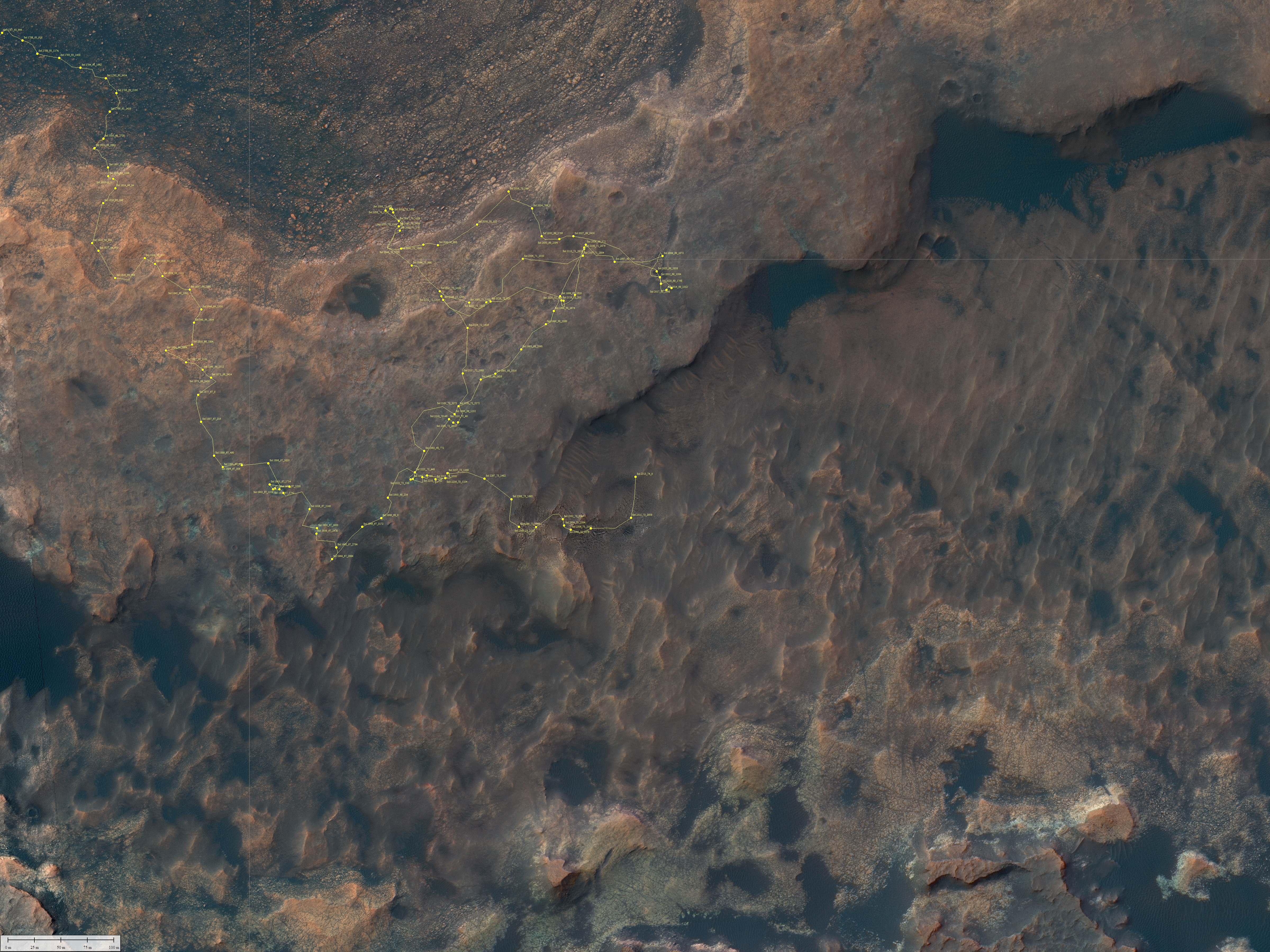
** Rovers on Mars and the Moon:  Bob Zimmerman gives an update on Curiosity as it slowly ascends Mt Sharp and on China’s Yutu-2 rover on the lunar surface: Rover update: February 20, 2019 | Behind The Black

The valley that Curiosity is presently traversing is dubbed “the clay unit” or “the clay-bearing unit” by the geologists, based on its make-up determined from orbital data. So far they have found this terrain to be “some of the best driving terrain we’ve encountered in Gale Crater, with just some occasional sandy patches in the lee of small ridges.” Initially they had problems finding any rocks or pebbles large enough for the instruments to use for gathering geological data. For the past week or so, however, they have stopped at “bright exposure of rock” where some bedrock was visible, giving them much better material to work with.

Click to see Curiosity’s track for past couple of years.

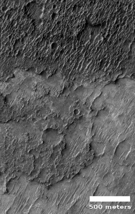
** Mars once had rivers flowing on its surface as shown by river beds seen from orbit. But up close images of the river beds show that it has been billions of years since water flowed over them: A river valley floor on Mars | Behind The Black

The floor of a canyon in Reull Vallis.

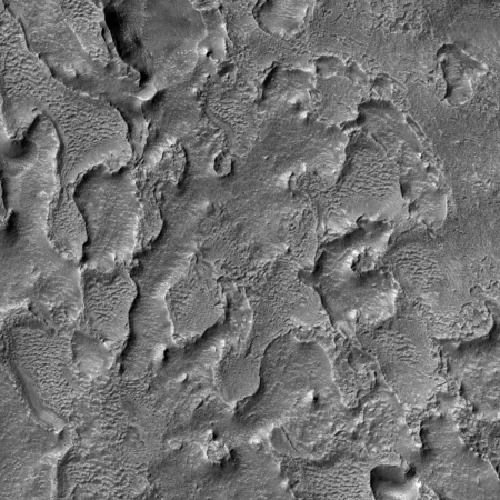
Here we see that the floor has been significantly eroded by later processes after the water disappeared. Later, wind action, which probably contributed to that erosion, also placed dust and dunes within the depressions here.

A lot of time has passed since that river flowed through Reull Valles. Or to put it another way, Mars has generally been a very dry place for a very long time. It might have considerable water at its poles as well hidden in an underground ice aquifer, but its surface is far drier than any desert on Earth, and has been for eons.

** Odd looking surface features on Mars are not uncommon. Here Bob examines an unusual pit that he spotted in an image of the south pole: Strange crescent-shaped pit near Martian south pole | Behind The Black

I found it in the February image release from the high resolution camera on Mars Reconnaissance Orbiter. I have merely cropped the full image to focus at full resolution on its primary feature, a region of stippled-like surface surrounding an area of black striping that in turn surrounds a crescent-shaped pit outlined by whiter material.

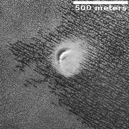
Why is there a pit here? Why is it crescent-shaped? Why is it surrounded by that whiter material? I could guess and say that the pit is a vent from which water vapor from the lower cap of water sprays out onto the upper cap of frozen carbon dioxide, staining it with white ice, but I am most likely wrong.

Moreover, what causes the black striping, as well as the stippled material surrounding it? The black stripes are probably related to a similar process that forms the spider formations found in the polar regions, except that these are not spiders. Why the parallel straight lines?

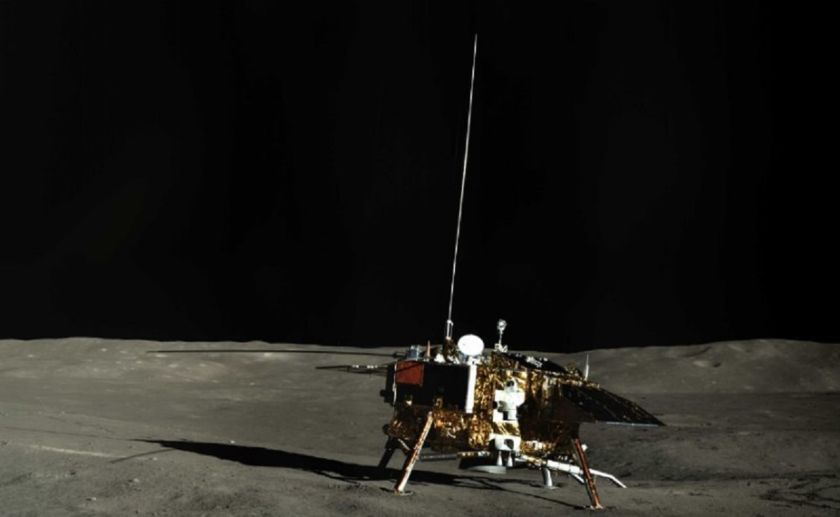
** The Chinese Chang’e 4 lander & rover on the far side of the Moon are currently in hibernation during the 2 week long lunar night. The Lunar Reconnaissance Orbiter has posted images of the pair taken during a pass over its location:

On 30 January LROC acquired a spectacular limb shot centered on the Chang’e 4 landing site, looking across the floor of Von Kármán crater. At the time, LRO was more than 200 kilometers from the landing site so Chang’e 4 was only a few pixels across and the rover was not discernable. The following day LRO was closer to the  site and again slewed (59° this time) to capture another view. This time the small Yutu-2 rover shows up (two pixels) just north of the lander. Also, shadows cast by the lander and rover are now visible.
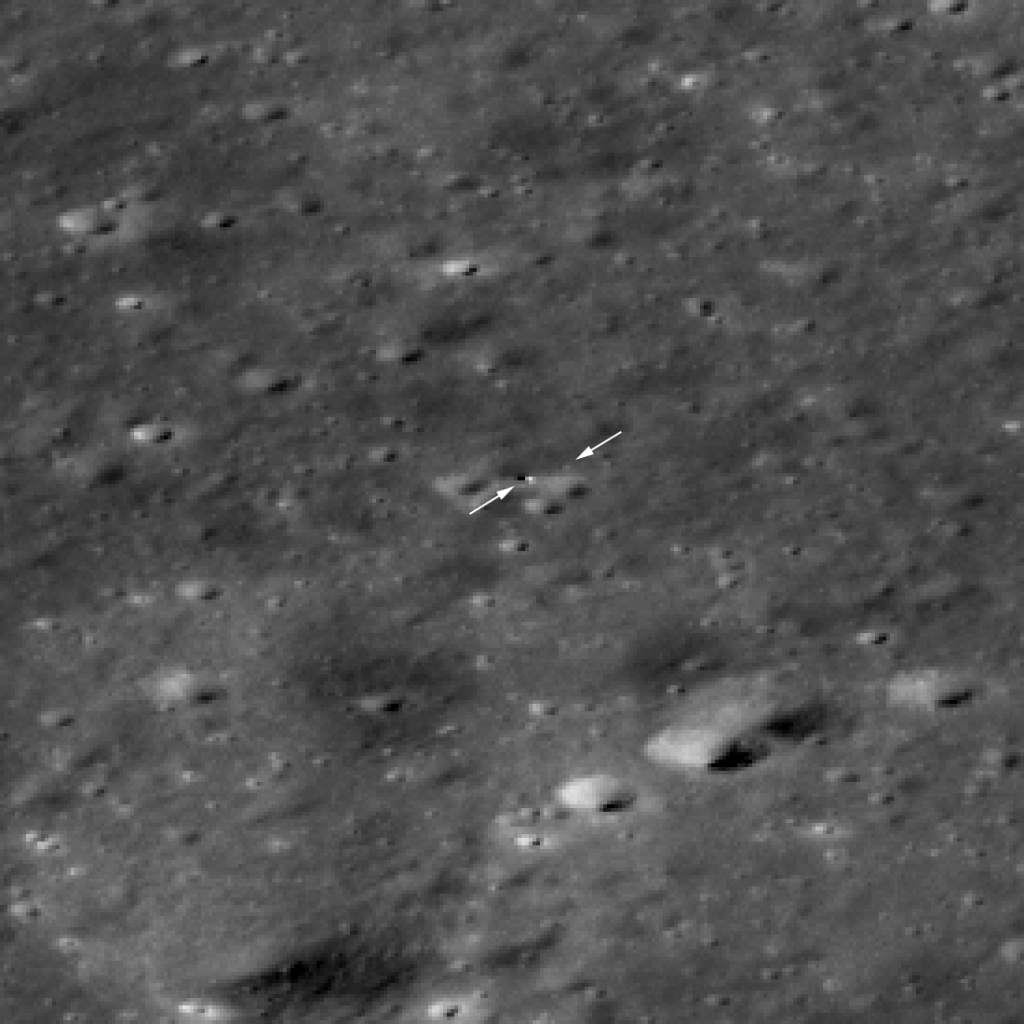
“The Chang’e 4 rover is now visible to LROC! Just beyond the tip of the right arrow is the rover and the lander is to the right of the tip of the left arrow. The image appears blocky because it is enlarged 4x to make it easier to see the two vehicles. North is to the upper right, LROC NAC M1303570617LR [NASA/GSFC/Arizona State University].”

The official Chinese lunar exploration website doesn’t appear to offer an English version but your can always use the Google translation.

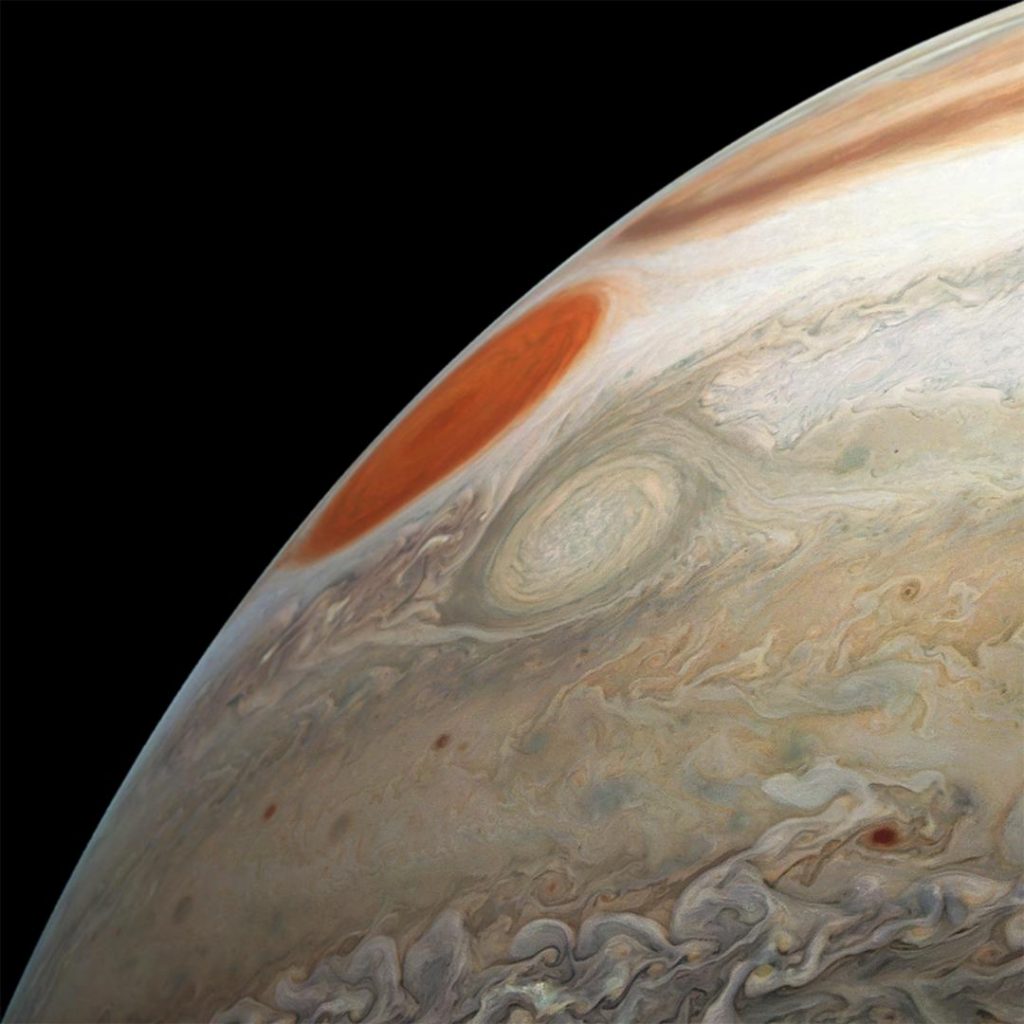
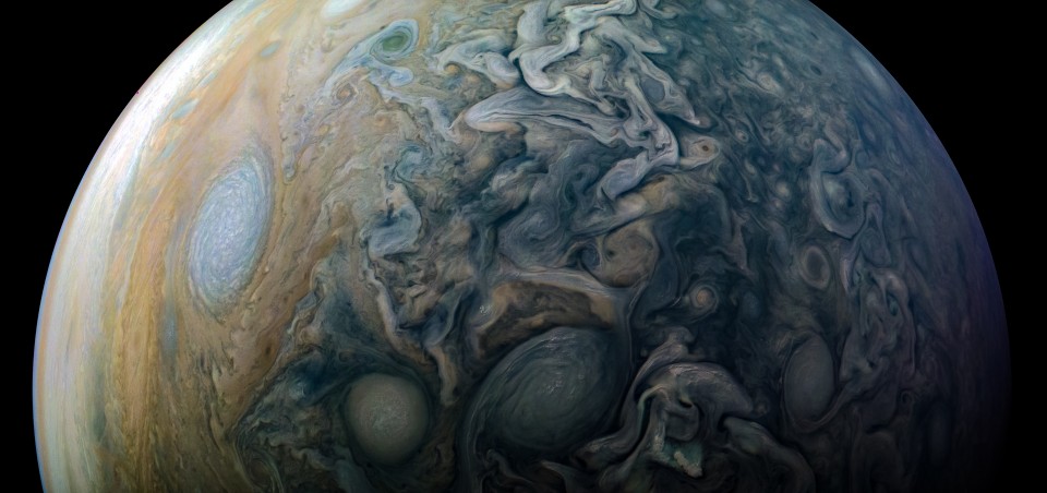
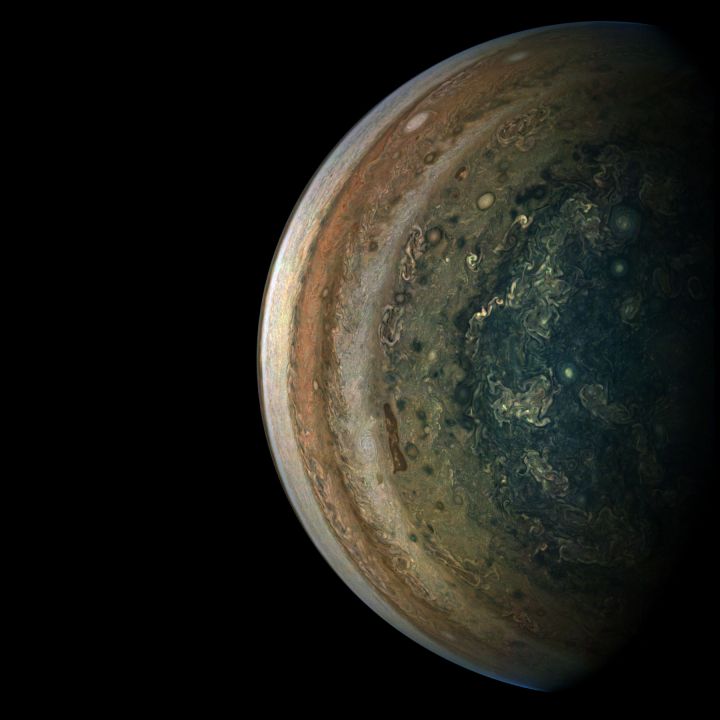
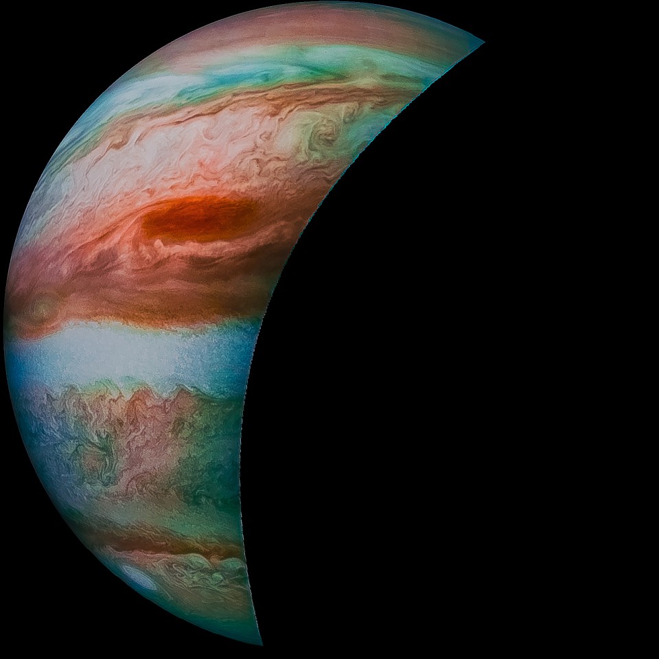
** Fly around Jupiter – Here is a cool time-lapse of images from the Juno probe as it made its 17th close pass above Jupiter’s clouds: ‘Juno’s Perijove-17 Jupiter Flyby, Reconstructed in 125-Fold Time-Lapse’ | JunoCam : Processing | Mission Juno

Via Movie of Juno’s December 2018 Jupiter fly-by | Behind The Black.

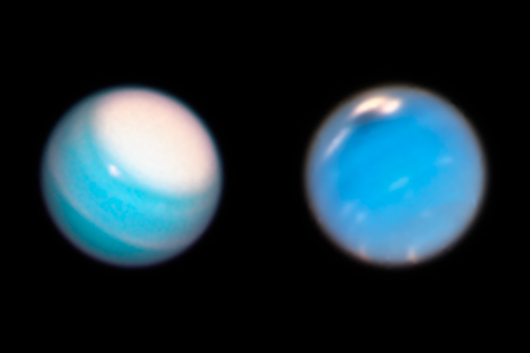
** A Neptune moon is a chip off the old Proteus moon according to a new report based on Hubble telescope imaging: Tiny Neptune Moon Spotted by Hubble May Have Broken from Larger Moon | NASA

Astronomers call it “the moon that shouldn’t be there.”

After several years of analysis, a team of planetary scientists using NASA’s Hubble Space Telescope has at last come up with an explanation for a mysterious moon around Neptune that they discovered with Hubble in 2013.

The tiny moon, named Hippocamp, is unusually close to a much larger Neptunian moon called Proteus. Normally, a moon like Proteus should have gravitationally swept aside or swallowed the smaller moon while clearing out its orbital path.

So why does the tiny moon exist? Hippocamp is likely a chipped-off piece of the larger moon that resulted from a collision with a comet billions of years ago. The diminutive moon, only 20 miles (about 34 kilometers) across, is 1/1000th the mass of Proteus (which is 260 miles [about 418 kilometers] across).

** The Moon receives a constant shower of solar protons, which can interact with oxygen in surface rocks with oxygen-bearing molecules to produce hydroxyl (OH), which needs just one more proton to become water (H2O):  NASA Finds Moon Could Be a Chemical Factory for Water | NASA

When a stream of charged particles known as the solar wind careens onto the Moon’s surface at 450 kilometers per second (or nearly 1 million miles per hour), they enrich the Moon’s surface in ingredients that could make water, NASA scientists have found.

Using a computer program, scientists simulated the chemistry that unfolds when the solar wind pelts the Moon’s surface. As the Sun streams protons to the Moon, they found, those particles interact with electrons in the lunar surface, making hydrogen (H) atoms. These atoms then migrate through the surface and latch onto the abundant oxygen (O) atoms bound in the silica (SiO2) and other oxygen-bearing molecules that make up the lunar soil, or regolith. Together, hydrogen and oxygen make the molecule hydroxyl (OH), a component of water, or H2O.

“We think of water as this special, magical compound,” said William M. Farrell, a plasma physicist at NASA’s Goddard Space Flight Center in Greenbelt, Maryland, who helped develop the simulation. “But here’s what’s amazing: every rock has the potential to make water, especially after being irradiated by the solar wind.”

This has implications for lunar settlers:

A key ramification of the result, [NASA Goddard plasma physicist  William M. Farrell] said, is that every exposed body of silica in space — from the Moon down to a small dust grain — has the potential to create hydroxyl and thus become a chemical factory for water.

** Dark matters – On a recent episode of The Space Show (Fri, 02/15/2019)Dr. William Dawson of Lawrence Livermore National Laboratory (LLNL) discussed “dark matter, dark energy, physics research, black holes, research goals and legacy, gravitational waves, gravitational lensing and much more”.

====

Chasing New Horizons: Inside the Epic First Mission to Pluto

Space science roundup – Feb.9.2019

A sampling of items regarding planetary science, astronomy, and solar science:

** A solar cycle update from Bob Zimmerman:  Sunspot update January 2019: The early solar minimum | Behind The Black

January saw a slight uptick in sunspot activity, but the overall activity remains comparable to mid-2008, when the last prolonged solar minimum began. If you go to my October 2018 update, you can see the graph when it included data going back to 2000 and see the entire last minimum.

That last minimum started in the last half of 2007, and lasted until mid-2009, a full two years. If you look at the red line prediction of the solar science community, it appears that they are expecting this coming minimum to last far longer, almost forever. I expect this is not really true, but that they have simply not agreed on a prediction for the next cycle. Some in that solar science community have hypothesized that we are about to enter a grand minimum, with no sunspots for decades and thus no solar maximum. Others do not agree.

** Mark Showalter,  New Horizons Hazard team lead and SETI Institute Senior Scientist, discusses “the spacecraft’s flyby of Ultima Thule, what it’s like working on the Hazards team, and even the naming of some of Pluto’s surface features” with SETI Institute chief Bill Diamond:

*** Ultima Thule has flat lobes according to further analysis of the image data from the fly-by of the Kuiper Belt object: New Horizons’ Evocative Farewell Glance at Ultima Thule: Images Confirm the Kuiper Belt Object’s Highly Unusual, Flatter Shape – New Horizons

This animation depicts a shape model of Ultima Thule created by the New Horizons science team based on its analysis of all the pre-flyby images sent to Earth so far. The first half of the movie mimics the view from the New Horizons spacecraft as it approached Ultima Thule and has the “snowman” shape that was so frequently mentioned in the days surrounding the New Year’s 2019 flyby.

The movie then rotates to a side-view that illustrates what New Horizons might have seen had its cameras been pointing toward Ultima Thule only a few minutes after closest approach. While that wasn’t the case, mission scientists have been able to piece together a model of this side-view, which has been at least partially confirmed by a set of crescent images of Ultima Thule (link). There is still considerable uncertainty in the sizes of “Ultima” (the larger section, or lobe) and “Thule” (the smaller) in the vertical dimension, but it’s now clear that Ultima looks more like a pancake than a sphere, and that Thule is also very non-spherical.

** Mars:

NASA’s Curiosity Mars Rover has already descended from Vera Rubin Ridge, a region of Mount Sharp that it has been exploring for more than a year. But before it left, the rover took a 360-degree panorama of the area depicting its last drill hole on the ridge (at a location called “Rock Hall”), a new region it will spent the next year exploring (the clay unit) and its last view of Gale Crater’s floor until it starts ascending in elevation again.

At high resolution there does not appear to be much difference between the darker and lighter areas. The lighter areas in general seem less rough and at a slightly lower elevation, but both areas are dominated by ridges and dunes trending southwest-to-northeast.

Why is this slightly higher region darker? Let’s assume that this darker material was a lava flow overlaying the surface. Over eons wind erosion, trending southwest-to-northwest, roughly eroded both it and the lower layers around it, leaving behind this rough corroded terrain. The different make-up of the darker material allows it to erode in a rougher manner.

While possibly correct, I would not bet much money on this guess. It is not clear it is lava. It is not clear that it is a flow. It does not explain why there are two areas of different darkness. And it certainly not clear what the make-up of any of this stuff is.

This is simply another cool mystery on the Martian surface.

Martian southern highlands region showing contrast between lighter and darker tinted areas.

** Moon:

Chang’e-4 lander as seen from the Yutu-2 rover.

** Uranus and Neptune are more interesting than we thought, new images show | Berkeley News

NASA’s Hubble Space Telescope has snapped the latest weather pictures of our solar system’s frigid outer planets, and UC Berkeley astronomers have jumped in to interpret them.

Giant polar cap dominates Uranus; dark tempest is raging on Neptune.

The new images, taken as part of a yearly monitoring program, show that a dark storm has appeared in Neptune’s northern hemisphere, the fourth seen on the planet since 1993, all of which appear and fade within a few years. UC Berkeley undergraduate student Andrew Hsu, who led a study of the latest images with associate research astronomer Michael Wong, estimates that the dark spots appear every four to six years at different latitudes and disappear after about two years.

It’s unclear how the storms form, Hsu said, but like Jupiter’s Great Red Spot, the dark vortices swirl in an anti-cyclonic direction and seem to dredge up material from deeper levels in the ice giant’s atmosphere. The latest storm was captured by Hubble in September 2018 and is roughly 6,800 miles across.

The new snapshot of Uranus gives a fresh look at a long-lived storm circling around the north-pole region of Uranus, a planet that is usually thought of as featureless and boring.

More at Hubble Reveals Dynamic Atmospheres of Uranus and Neptune – HubbleSite

** Asteroids – The DART mission will smack an asteroid with a spacecraft to test deflection capabilities:  The DART Mission: Learning How to Swat Dangerous Asteroids | The Planetary Society

Why did the dinosaurs die? They didn’t have a space program! The upcoming DART mission will test our best thinking about how we may someday deflect a Near Earth Object that is speeding toward fiery Armageddon on Earth. Nancy Chabot of the JHU Applied Physics Lab is the mission’s Coordination Lead.

** Science news is included in the latest TMRO.tv space news report: SpaceX Engine Tests, ISRO Spaceflight, Lunar Craters and SpaceIL

====


Check out the Best Selling Electronics at Amazon

Space science: Deep water on Mars, Rovers update, & Juno mission midway

A sampling of planetary science news:

** Yet more Mars water: A new study finds evidence for a deep groundwater table on Mars: Well water likely available across Mars | Behind The Black

A science paper released today and available for download [pdf] cites evidence from about two dozen deep impact craters located from the equator to 37 degrees north latitude that Mars has a ground ice table at an elevation that also corresponds to other shoreline features.

The third take-away from this paper however is possibly the most important. The evidence suggests that this deep groundwater water table (as ice) almost certainly still exists at all latitudes, though almost entirely underground. From a future explorer’s perspective, this data reinforces the possibility that water will be accessible across much of the Martian surface. All you will have to do is dig a well, something humans have been doing on Earth for eons.

Diagram of surface feature evidence for a deep ground water table

** Curiosity on the move:  The Curiosity rover continues its long slow methodical trek up Mount Sharp – Curiosity Says Farewell to Mars’ Vera Rubin Ridge | NASA

NASA’s Curiosity rover has taken its last selfie on Vera Rubin Ridge and descended toward a clay region of Mount Sharp. The twisting ridge on Mars has been the rover’s home for more than a year, providing scientists with new samples — and new questions — to puzzle over.

On Dec. 15, Curiosity drilled its 19th sample at a location on the ridge called Rock Hall. On Jan. 15, the spacecraft used its Mars Hand Lens Imager (MAHLI) camera on the end of its robotic arm to take a series of 57 pictures, which were stitched together into this selfie. The “Rock Hall” drill hole is visible to the lower left of the rover; the scene is dustier than usual at this time of year due to a regional dust storm.

Curiosity has been exploring the ridge since September of 2017. It’s now headed into the “clay-bearing unit,” which sits in a trough just south of the ridge. Clay minerals in this unit may hold more clues about the ancient lakes that helped form the lower levels on Mount Sharp.

A selfie taken by NASA’s Curiosity Mars rover on Sol 2291 (January 15) at the “Rock Hall” drill site, located on Vera Rubin Ridge. Credits: NASA/JPL-Caltech/MSSS Full image and caption

** Last hope for Opportunity: NASA JPL will try some new techniques in hopes of awakening the long silent Opportunity rover – Rover Team Beaming New Commands to Opportunity on Mars – NASA JPL

Engineers at NASA’s Jet Propulsion Laboratory in Pasadena, California, have begun transmitting a new set of commands to the Opportunity rover in an attempt to compel the 15-year-old Martian explorer to contact Earth. The new commands, which will be beamed to the rover during the next several weeks, address low-likelihood events that could have occurred aboard Opportunity, preventing it from transmitting.

The rover’s last communication with Earth was received June 10, 2018, as a planet-wide dust storm blanketed the solar-powered rover’s location on Mars.

“We have and will continue to use multiple techniques in our attempts to contact the rover,” said John Callas, project manager for Opportunity at JPL. “These new command strategies are in addition to the ‘sweep and beep’ commands we have been transmitting up to the rover since September.” With “sweep and beep,” instead of just listening for Opportunity, the project sends commands to the rover to respond back with a beep.

** Juno midway in Jupiter mission: The Juno spacecraft in December completed its 16th orbit of Jupiter, halfway to the 32 orbit target to complete its primary mission – NASA’s Juno Mission Halfway to Jupiter Science | NASA

“With our 16th science flyby, we will have complete global coverage of Jupiter, albeit at coarse resolution, with polar passes separated by 22.5 degrees of longitude,” said Jack Connerney, Juno deputy principal investigator from the Space Research Corporation in Annapolis, Maryland. “Over the second half of our prime mission — science flybys 17 through 32 — we will split the difference, flying exactly halfway between each previous orbit. This will provide coverage of the planet every 11.25 degrees of longitude, providing a more detailed picture of what makes the whole of Jupiter tick.”

Launched on Aug. 5, 2011, from Cape Canaveral, Florida, the spacecraft entered orbit around Jupiter on July 4, 2016. Its science collection began in earnest on the Aug. 27, 2016, flyby. During these flybys, Juno’s suite of sensitive science instruments probes beneath the planet’s obscuring cloud cover and studies Jupiter’s auroras to learn more about the planet’s origins, interior structure, atmosphere and magnetosphere.

“We have already rewritten the textbooks on how Jupiter’s atmosphere works, and on the complexity and asymmetry of its magnetic field,” said Scott Bolton, principal investigator of Juno, from the Southwest Research Institute in San Antonio. “The second half should provide the detail that we can use to refine our understanding of the depth of Jupiter’s zonal winds, the generation of its magnetic field, and the structure and evolution of its interior.”

** A sampling of recent images from Juno:

**** Juno’s SRU Captures Jupiter Lightning

Juno’s Radiation Monitoring Investigation used the Stellar Reference Unit (SRU) star camera to collect this high-resolution image Jupiter’s northern auroral oval on May 24, 2018 (Perijove 13). Also present in the image are several small bright dots and streaks — signatures of high energy relativistic electrons from polar beams that are penetrating the camera. The large bright dot in the lower right corner of the image is a flash of Jupiter’s lightning. Juno was less than 37,000 miles (60,000 km) from the cloud tops when this SRU image was collected — the closest view of Jupiter’s aurora with a visible light imager.

**** Juno’s Latest Flyby of Jupiter Captures Two Massive Storms

“This image of Jupiter’s turbulent southern hemisphere was captured by NASA’s Juno spacecraft as it performed its most recent close flyby of the gas giant planet on Dec. 21, 2018. This new perspective captures the notable Great Red Spot, as well as a massive storm called Oval BA. The storm reached its current size when three smaller spots collided and merged in the year 2000. The Great Red Spot, which is about twice as wide as Oval BA, may have formed from the same process centuries ago.” – NASA JPL

**** PJ12-83 – Jupiter during Perijove 17

Jupiter during Juno 17th orbit. Credits: Kevin M. Gill at Junocam public image processing gallery
**** Jupiter at home in the Milky Way

“Jupiter at Home in the Milky Way” – Credits: CosmEffect at  Junocam public image processing gallery
See also

====

Chasing New Horizons: Inside the Epic First Mission to Pluto

New images and video from Juno at Jupiter

More cool views of Jupiter via Juno images enhanced by citizen scientists:

** Jupiter in the Rearview Mirror | Mission Juno

In the final minutes of a recent close flyby of Jupiter, NASA’s Juno spacecraft captured a departing view of the planet’s swirling southern hemisphere. This color-enhanced image was taken at 7:13 p.m. PDT on Sept. 6, 2018 (10:13 p.m. EDT) as the spacecraft performed its 15th close flyby of Jupiter. At the time, Juno was about 55,600 miles (89,500 kilometers) from the planet’s cloud tops, above a southern latitude of approximately 75 degrees.  Citizen scientist Gerald Eichstädt created this image using data from the spacecraft’s JunoCam imager. Image Credits: NASA/JPL-Caltech/SwRI/MSSS/Gerald Eichstädt

** Juno’s Perijove-15 Jupiter Flyby, Reconstructed in 125-Fold Time-LapseGerald Eichstädt

From the caption:

Early on September 07, 2018, UTC, NASA’s Juno probe successfully performed her Perijove-15 Jupiter flyby. Like during most of the recent Jupiter flybys, good contact to Earth and incremented storage allowed taking close-up images of good quality.

The movie is a reconstruction of the 112 minutes between 2018-09-07T00:30:00.000 and 2018-09-07T02:22:00.000 in 125-fold time-lapse.
It is based on 25 of the JunoCam images taken, and on spacecraft trajectory data provided via SPICE kernel files.

In steps of five real-time seconds, one still images of the movie has been rendered from at least one suitable raw image. This resulted in short scenes, usually of a few seconds. Playing with 25 images per second results in 125-fold time-lapse.

** Let Me See What Spring Is Like On Jupiter And MarsMoshe16

====

Chasing New Horizons: Inside the Epic First Mission to Pluto


Audio: Hear the radio emissions of Saturn and its moon Enceladus

Check out the exotic sounds of Saturn as derived from the radio transmissions generated by waves in the plasma (ionized particles) between Saturn and the rings and the satellite Enceladus:

Listen: Electromagnetic Energy of Saturn, Enceladus

New research from NASA’s Cassini spacecraft’s up-close Grand Finale orbits shows a surprisingly powerful and dynamic interaction of plasma waves moving from Saturn to its rings and its moon Enceladus. The observations show for the first time that the waves travel on magnetic field lines connecting Saturn directly to Enceladus. The field lines are like an electrical circuit between the two bodies, with energy flowing back and forth.

Researchers converted the recording of plasma waves into a “whooshing” audio file that we can hear — in the same way a radio translates electromagnetic waves into music. In other words, Cassini detected electromagnetic waves in the audio frequency range — and on the ground, we can amplify and play those signals through a speaker. The recording time was compressed from 16 minutes to 28.5 seconds.

Much like air or water, plasma (the fourth state of matter) generates waves to carry energy. The Radio Plasma Wave Science (RPWS) instrument on board NASA’s Cassini spacecraft recorded intense plasma waves during one of its closest encounters to Saturn.

“Enceladus is this little generator going around Saturn, and we know it is a continuous source of energy,” said Ali Sulaiman, planetary scientist at the University of Iowa, Iowa City, and a member of the RPWS team. “Now we find that Saturn responds by launching signals in the form of plasma waves, through the circuit of magnetic field lines connecting it to Enceladus hundreds of thousands of miles away.”

Sulaiman is lead author of a pair of papers describing the findings, published recently in Geophysical Research Letters.

The interaction of Saturn and Enceladus is different from the relationship of Earth and its Moon. Enceladus is immersed in Saturn’s magnetic field and is geologically active, emitting plumes of water vapor that become ionized and fill the environment around Saturn. Our own Moon does not interact in the same way with Earth. Similar interactions take place between Saturn and its rings, as they are also very dynamic.

The recording was captured Sept. 2, 2017, two weeks before Cassini was deliberately plunged into the atmosphere of Saturn. The recording was converted by the RPWS team at the University of Iowa, led by physicist and RPWS Principal Investigator Bill Kurth.

The GRL research is available on the American Geophysical Union’s website:

The Cassini-Huygens mission is a cooperative project of NASA, ESA (European Space Agency) and the Italian Space Agency. NASA’s Jet Propulsion Laboratory, a division of Caltech in Pasadena, manages the mission for NASA’s Science Mission Directorate, Washington. JPL designed, developed and assembled the Cassini orbiter. The RPWS instrument was built by the University of Iowa, working with team members from the U.S. and several European countries.

Gretchen McCartney
Jet Propulsion Laboratory, Pasadena, California
818-393-6215
Gretchen.P.McCartney@jpl.nasa.gov

Dwayne Brown / JoAnna Wendel
NASA Headquarters, Washington
202-358-1726 / 202-358-1003
dwayne.c.brown@nasa.gov / joanna.r.wendel@nasa.gov

=====