Images from the European Proba-V earth observation smallsat shows changes in African during the rainy season:
Space in Images – 2017 – 07 – Proba-V monitors African Sahel
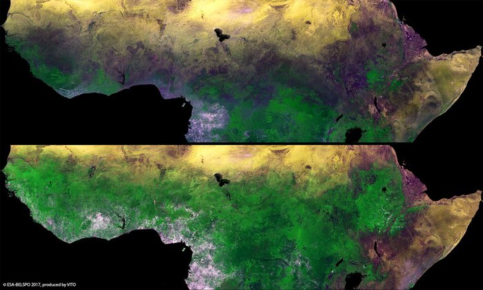
ESA’s Proba-V minisatellite reveals the seasonal changes in Africa’s sub-Saharan Sahel, with the rainy season allowing vegetation to blossom between February (top) and September (bottom).
The semi-arid Sahel stretches more than 5000 km across Africa, from the Atlantic Ocean (Senegal, Mauritania) to the Red Sea (Sudan). The few months of the rainy season in the Sahel are much needed in these hot and sunny parts of Africa, and are critical for the food security and livelihood of their inhabitants.
The name Sahel can be translated from Arabic as coast or shore, considered as the ever-shifting landward ‘coastline’ of the arid Sahara Desert.
Smaller than a cubic metre, Proba-V nevertheless images the entire land surface of Earth every two days or less, allowing researchers around the globe to trace gradual shifts in vegetation.
A new set of timelapse videos shows the power of such rapid-repeat views.
Launched on 7 May 2013, Proba-V is a miniaturised ESA satellite tasked with a full-scale mission: to map land cover and vegetation growth across the entire planet every two days.
Its main camera’s continent-spanning 2250 km swath width collects light in the blue, red, near-infrared and mid-infrared wavebands at 300 m resolution and down to 100 m resolution in its central field of view.
VITO Remote Sensing in Belgium processes and then distributes Proba-V data to users worldwide. An online image gallery highlights some of the mission’s most striking images so far, including views of storms, fires and deforestation.
====
One thought on “Video: Satellite shows African greenery expand and recede as rains come and go”
Comments are closed.