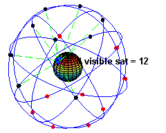
The Global Positioning System or GPS has become like weather imaging and Direct-to-Home TV – another space application that is pervasive in our lives and yet taken totally for granted. Most of the public now uses GPS routinely on cell phones but is not aware that GPS is enabled by a constellation of satellites.
The Satellite Lamps art/education project by designers Einar Sneve Martinussen, Jørn Knutsen, and Timo Arnall that aims to “illuminate” how the otherwise invisible GPS is actually a dynamic, variable, and active system. Their approach involves a set of lamps whose brightness depends on the strength of GPS signals detected by a receiver attached to each lamp.
As the satellites go in and out of view of the receivers, the lamp’s glow will vary. This is particularly so in cities where tall structures limit direct views of the sky.
The project is outlined at Kairos 19.1: Martinussen et al, Satellite Lamps – Introduction
In Satellite Lamps, practices and languages of design are put to use to explain and situate the phenomena of GPS. We use photography, filmmaking and fieldwork, electronics and product design, as well as design observations on culture and technology to explore some of the ways in which GPS can be communicated and understood.
This short film also describes the project:
More at Illuminated Orbs Embedded with GPS Receivers Visualize Satellite Technology – PSFK