The outer reaches of our Solar System are home to hundreds of thousands of small icy worlds. Their present orbits are a sculpted signature of the early migrations of the giant planets, particularly Neptune. Yet the faintness and highly eccentric orbits of most of these worlds mean only a tiny fraction of them have yet been discovered.
With the Outer Solar System Origins Survey on CFHT, we are discovering up to five hundred new outer Solar System objects, with exquisitely well-determined orbital parameters. Our complementary Large Program on Gemini North is observing the brightest of our discoveries in the optical and infrared with unprecedented precision, providing information on the ices, silicates and organic compounds on the surfaces of these small worlds.
This colourful map of the structure of the outer Solar System is providing new constraints on Neptune’s migration.
A year ago, Pluto was just a bright speck in the cameras of NASA’s approaching New Horizons spacecraft, not much different than its appearances in telescopes since Clyde Tombaugh discovered the ninth planet in 1930.
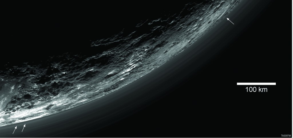
This image of haze layers above Pluto’s limb was taken by the Ralph/Multispectral Visible Imaging Camera (MVIC) on NASA’s New Horizons spacecraft. About 20 haze layers are seen; the layers have been found to typically extend horizontally over hundreds of kilometers, but are not strictly parallel to the surface. For example, white arrows indicate a haze layer about three miles (five kilometers) above the surface on the left, which has descended to the surface at the right. Credit: NASA/Johns Hopkins University Applied Physics Laboratory/Southwest Research Institute/AAAS/Science
But this week, in the journal Science, New Horizons scientists published the first comprehensive set of papers describing results from last summer’s Pluto system flyby. “These five detailed papers completely transform our view of Pluto – revealing the former ‘astronomer’s planet’ to be a real world with diverse and active geology, exotic surface chemistry, a complex atmosphere, puzzling interaction with the sun and an intriguing system of small moons,” said Alan Stern, New Horizons principal investigator from Southwest Research Institute, Boulder, Colorado.
After a 9.5-year, 3-billion-mile journey – launching faster and traveling farther than any spacecraft to reach its primary target – New Horizons zipped by Pluto on July 14, 2015. New Horizons’ seven science instruments collected about 50 gigabits of data on the spacecraft’s digital recorders, most of it coming over nine busy days surrounding the encounter. About half of that data has now been transmitted home – from distances where radio signals at light speed need nearly five hours to reach Earth – with all of it expected back by October.
New Horizons views of the informally named Sputnik Planum on Pluto (top) and the informally named Vulcan Planum on Charon (bottom). Both scale bars measure 20 miles (32 kilometers) long; illumination is from the left in both instances. The Sputnik Planum view is centered at 11°N, 180°E, and covers the bright, icy, geologically cellular plains. Here, the cells are defined by a network of interconnected troughs that crisscross these nitrogen-ice plains. At right, in the upper image, the cellular plains yield to pitted plains of southern Sputnik Planum. This observation was obtained by the Ralph/Multispectral Visible Imaging Camera (MVIC) at a resolution of 1,050 feet (320 meters) per pixel. The Vulcan Planum view in the bottom panel is centered at 4°S, 4°E, and includes the “moated mountain” Clarke Mons just above the center of the image. As well as featuring impact craters and sinuous troughs, the water ice-rich plains display a range of surface textures, from smooth and grooved at left, to pitted and hummocky at right. This observation was obtained by the Long Range Reconnaissance Imager (LORRI) at a resolution of 525 feet (160 meters) per pixel. Credit: NASA/Johns Hopkins University Applied Physics Laboratory/Southwest Research InstituteThe first close-up pictures revealed a large heart-shaped feature carved into Pluto’s surface, telling scientists that this “new” type of planet – the largest, brightest and first-explored in the mysterious, distant “third zone” of our solar system known as the Kuiper Belt – would be even more interesting and puzzling than models predicted.
“Observing Pluto and Charon up close has caused us to completely reassess thinking on what sort of geological activity can be sustained on isolated planetary bodies in this distant region of the solar system, worlds that formerly had been thought to be relics little changed since the Kuiper Belt’s formation,” said Jeff Moore, from NASA Ames Research Center, California, and lead author of the paper covering geology.
This enhanced color view of Pluto’s surface diversity was created by merging Ralph/Multispectral Visible Imaging Camera (MVIC) color imagery (650 meters per pixel) with Long Range Reconnaissance Imager panchromatic imagery (230 meters per pixel). At lower right, ancient, heavily cratered terrain is coated with dark, reddish tholins. At upper right, volatile ices filling the informally named Sputnik Planum have modified the surface, creating a chaos-like array of blocky mountains. Volatile ice also occupies a few nearby deep craters, and in some areas the volatile ice is pocked with arrays of small sublimation pits. At left, and across the bottom of the scene, gray-white CH4 ice deposits modify tectonic ridges, the rims of craters, and north-facing slopes. The scene in this image is 260 miles (420 kilometers) wide and 140 miles (225 kilometers) from top to bottom; north is to the upper left. Credit: NASA/Johns Hopkins University Applied Physics Laboratory/Southwest Research InstituteScientists studying Pluto’s composition say the diversity of the planet’s landscape stems from eons of interaction between highly volatile and mobile methane, nitrogen and carbon monoxide ices with inert and sturdy water ice. “We see variations in the distribution of Pluto’s volatile ices that point to fascinating cycles of evaporation and condensation,” said Will Grundy, from Lowell Observatory in Flagstaff, Arizona, and lead author of the composition paper. “These cycles are a lot richer than on Earth, where there’s really only one material that condenses and evaporates – water. On Pluto, there are least three materials, and while they interact in ways we don’t yet fully understand, we definitely see their effects all across Pluto’s surface.”
Above the surface, scientists discovered Pluto’s atmosphere contains layered hazes, and is both cooler and more compact than expected. This affects how Pluto’s upper atmosphere is lost to space, and how it interacts with the stream of charged particles from the sun known as the solar wind. “We’ve discovered that pre-New Horizons estimates wildly overestimated the loss of material from Pluto’s atmosphere,” said Fran Bagenal, from the University of Colorado, Boulder, and lead author on the particles and plasma paper. “The thought was that Pluto’s atmosphere was escaping like a comet, but it is actually escaping at a rate much more like Earth’s atmosphere.”
Randy Gladstone, of SwRI, San Antonio, and the lead author of the Science paper on atmospheric findings, added, “We’ve also discovered that methane, rather than nitrogen, is Pluto’s primary escaping gas. This is pretty surprising, since near Pluto’s surface the atmosphere is more than 99-percent nitrogen.”
Scientists are also analyzing the first close-up images of Pluto’s small moons Styx, Nix, Kerberos, and Hydra. Discovered between 2005 and 2012, the four moons range in diameter from about 25 miles (40 kilometers) for Nix and Hydra to about six miles (10 kilometers) for Styx and Kerberos. Mission scientists further observed that the small satellites have highly anomalous rotation rates and uniformly unusual pole orientations, as well as icy surfaces with brightness and colors distinctly different from those of Pluto and Charon.
They’ve also found evidence that some of the moons resulted from mergers of even smaller bodies, and that their surface ages date back at least 4 billion years. “These latter two results reinforce the hypothesis that the small moons formed in the aftermath of a collision that produced the Pluto-Charon binary system,” said Hal Weaver, New Horizons project scientist from the Johns Hopkins University Applied Physics Laboratory in Laurel, Maryland, and lead author of the Science paper on Pluto’s small moons.
“This is why we explore,” said Curt Niebur, New Horizons program scientist at NASA Headquarters in Washington. “The many discoveries from New Horizons represent the best of humankind and inspire us to continue the journey of exploration to the solar system and beyond.”
New Horizons is part of NASA’s New Frontiers Program, managed by the agency’s Marshall Space Flight Center in Huntsville, Alabama. The Johns Hopkins Applied Physics Laboratory designed, built, and operates the New Horizons spacecraft and manages the mission for NASA’s Science Mission Directorate. The Southwest Research Institute leads the science mission, payload operations, and encounter science planning.
Pluto’s largest moon may have gotten too big for its own skin.
Image credit: NASA/Johns Hopkins University Applied Physics Laboratory/Southwest Research InstituteImages from NASA’s New Horizons mission suggest that Charon once had a subsurface ocean that has long since frozen and expanded, pushing out on the moon’s surface and causing it to stretch and fracture on a massive scale.
The side of Charon viewed by the passing New Horizons spacecraft in July 2015 is characterized by a system of “pull apart” tectonic faults, which are expressed as ridges, scarps and valleys—the latter sometimes reaching more than 4 miles (6.5 kilometers) deep. Charon’s tectonic landscape shows that, somehow, the moon expanded in its past, and – like Bruce Banner tearing his shirt as he becomes the Incredible Hulk – Charon’s surface fractured as it stretched.
Charon’s outer layer is primarily water ice. When the moon was young this layer was warmed by the decay of radioactive elements, as well as Charon’s own internal heat of formation. Scientists say Charon could have been warm enough to cause the water ice to melt deep down, creating a subsurface ocean. But as Charon cooled over time, this ocean would have frozen and expanded (as happens when water freezes), pushing the surface outward and producing the massive chasms we see today.
This image focuses on a section of the feature informally named Serenity Chasma, part of a vast equatorial belt of chasms on Charon. In fact, this system of chasms is one of the longest seen anywhere in the solar system, running at least 1,100 miles (about 1,800 kilometers) long and reaching 4.5 miles (7.5 kilometers) deep. By comparison, the Grand Canyon is 277 miles (446 kilometers) long and just over a mile (1.6 kilometers) deep.
The lower portion of the image shows color-coded topography of the same scene. Measurements of the shape of this feature tell scientists that Charon’s water-ice layer may have been at least partially liquid in its early history, and has since refrozen.
This image was obtained by the Long-Range Reconnaissance Imager (LORRI) on New Horizons. North is up; illumination is from the top-left of the image. The image resolution is about 1,290 feet (394 meters) per pixel. The image measures 240 miles (386 kilometers) long and 110 miles (175 kilometers) wide. It was obtained at a range of approximately 48,900 miles (78,700 kilometers) from Charon, about an hour and 40 minutes before New Horizons’ closest approach to Charon on July 14, 2015.
Data from NASA’s New Horizons spacecraft point to more prevalent water ice on Pluto’s surface than previously thought.
This false-color image, derived from observations in infrared light by the Ralph/Linear Etalon Imaging Spectral Array (LEISA) instrument, shows where the spectral features of water ice are abundant on Pluto’s surface. It is based on two LEISA scans of Pluto obtained on July 14, 2015, from a range of about 67,000 miles (108,000 kilometers).
The scans, taken about 15 minutes apart, were stitched into a combined multispectral Pluto “data cube” covering the full hemisphere visible to New Horizons as it flew past Pluto. A data cube like this is a three-dimensional array in which an image of Pluto is formed at each LEISA-sensitive wavelength.
Water ice is Pluto’s crustal “bedrock,” the canvas on which its more volatile ices paint their seasonally changing patterns. Initial New Horizons maps of Pluto’s water ice bedrock compared LEISA spectra with a pure water ice template spectrum, resulting in the map at left.
A disadvantage of that technique is that water ice’s spectral signature is easily masked by methane ice, so that map was only sensitive to areas that were especially rich in water ice and/or depleted in methane. The much more sensitive method used on the right involves modeling the contributions of Pluto’s various ices all together. This method, too, has limitations in that it can only map ices included in the model, but the team is continually adding more data and improving the model.
The new map shows exposed water ice to be considerably more widespread across Pluto’s surface than was previously known — an important discovery. But despite its much greater sensitivity, the map still shows little or no water ice in the informally named places called Sputnik Planum (the left or western region of Pluto’s “heart”) and Lowell Regio (far north on the encounter hemisphere). This indicates that at least in these regions, Pluto’s icy bedrock is well hidden beneath a thick blanket of other ices such as methane, nitrogen and carbon monoxide.
Credit: NASA/Johns Hopkins University Applied Physics Laboratory/Southwest Research Institute
This image from NASA’s New Horizons spacecraft is the first look at Pluto’s atmosphere in infrared wavelengths, and the first image of the atmosphere made with data from the New Horizons Ralph/Linear Etalon Imaging Spectral Array (LEISA) instrument.
In this image, sunlight is coming from above and behind Pluto. The image was captured on July 14, 2015, while New Horizons was about 112,000 miles (180,000 kilometers) away. The image covers LEISA’s full spectral range (1.25 to 2.5 microns), which is divided into thirds, with the shortest third being put into the blue channel, middle third into the green channel, and longest into the red channel. North in this image is around the 10 o’clock position.
The blue ring around Pluto is caused by sunlight scattering from haze particles common in Pluto’s atmosphere; scientists believe the haze is a photochemical smog resulting from the action of sunlight on methane and other molecules, producing a complex mixture of hydrocarbons such as acetylene and ethylene. These hydrocarbons accumulate into small particles – a fraction of a micrometer in size – which scatter sunlight to make the blue haze. The new infrared image, when combined with earlier images made at shorter, visible wavelengths, gives scientists new clues into the size distribution of the particles.
The whitish patches around Pluto’s limb in this image are sunlight bouncing off more reflective or smoother areas on Pluto’s surface – with the largest patch being the western section of the informally named Cthulhu Regio. Future LEISA observations returned to Earth should capture the remainder of the haze, missing from the lower section of the image.
Credit: NASA/Johns Hopkins University Applied Physics Laboratory/Southwest Research Institute.
![Mountains%20Craters%20and%20Plains[1]](http://hobbyspace.com/Blog/wp-content/uploads/2016/03/Mountains20Craters20and20Plains1.jpg)
![Surface%20Diversity[1]](http://pluto.jhuapl.edu/Multimedia/Science-Photos/pics/Surface%20Diversity.jpg)
![Charon_SerenityChasma_Context_02182016_Melded[1]](http://hobbyspace.com/Blog/wp-content/uploads/2016/02/Charon_SerenityChasma_Context_02182016_Melded1-1024x555.jpg)
![Pluto_H2O_Ice_Composite[1]](http://pluto.jhuapl.edu/Multimedia/Science-Photos/pics/Pluto_H2O_Ice_Composite.jpg)
![LEISA-Atmosphere-Infrared[1]](http://hobbyspace.com/Blog/wp-content/uploads/2016/02/LEISA-Atmosphere-Infrared1.jpg)
![leisa_christmas_false_color[1]](http://hobbyspace.com/Blog/wp-content/uploads/2015/12/leisa_christmas_false_color1-1024x1024.png)