Category Archives: Space Science

Video: “A World Unveiled: Cassini at Titan”

The Cassini-Huygens mission ends on September 15th when the Cassini spacecraft will plunge into Saturn’s atmosphere. Looking back on the 13 years of exploring the Saturn system, the discoveries about Titan, on which the Huygens probe landed, were among the richest of the whole program: Cassini: The Grand Finale: Cassini Prepares to Say Goodbye to a True Titan

Saturn’s giant, hazy moon Titan has been essential to NASA’s Cassini mission during its 13 thrilling years of exploration there. Cassini and the European Huygens probe have revealed a fascinating world of lakes and seas, great swaths of dunes, and a complex atmosphere with weather – with intriguing similarities to Earth. Titan has also been an engine for the mission, providing gravity assists that propelled the spacecraft on its adventures around the ringed planet. For more about the Cassini-Huygens mission, visit https://saturn.jpl.nasa.gov

Over the course of its 13-year mission at Saturn, Cassini has made 127 close flybys of Titan, with many more-distant observations. Cassini also dropped off the European Space Agency’s Huygens probe, which descended through Titan’s atmosphere to land on the surface in January 2005.

Successes for Cassini during its mission include the revelation that, as researchers had theorized, there were indeed bodies of open liquid hydrocarbons on Titan’s surface. Surprisingly, it turned out Titan’s lakes and seas are confined to the poles, with almost all of the liquid being at northern latitudes in the present epoch. Cassini found that most of Titan has no lakes, with vast stretches of linear dunes closer to the equator similar to those in places like Namibia on Earth. The spacecraft observed giant hydrocarbon clouds hovering over Titan’s poles and bright, feathery ones that drifted across the landscape, dropping methane rain that darkened the surface. There were also indications of an ocean of water beneath the moon’s icy surface.

The instruments on Cassini allowed for seeing Titan in different ways: Cassini: The Grand Finale: Two Titans

These views were obtained with the Cassini spacecraft narrow-angle camera on March 21, 2017. Images taken using red, green and blue spectral filters were combined to create the natural-color view at left. The false-color view at right was made by substituting an infrared image (centered at 938 nanometers) for the red color channel.

These two views of Saturn’s moon Titan exemplify how NASA’s Cassini spacecraft has revealed the surface of this fascinating world. > Full image and caption

More about the final days of Cassini: Cassini: The Grand Finale: Cassini to Begin Final Five Orbits Around Saturn.

====

Videos: New views of the Red Planet from the Mars Reconnaissance Orbiter

Most everyday there are posts on HiRISE (NASA) (@HiRISE) | Twitter showing images (some in 3D) and videos made with the HiRISE (High Resolution Imaging Science Experiment) camera on the Mars Reconnaissance Orbiter.

For example, check out these marvelous landscapes:

Flow in the Hellas Montes Region from UAHiRISE on Vimeo.

====

Videos: Curiosity marks five years searching for clues to Mars early history

NASA JPL highlights the five year anniversary of the Curiosity Rover‘s arrival on Mars with a set of videos about the mission so far:

Five Years Ago and 154 Million Miles Away: Touchdown!

Five years since it landed near Mount Sharp on Mars in August 2017 and nearly three years since reaching the base of the mountain, NASA’s Curiosity Mars rover is climbing toward multiple layers of Mount Sharp visible in this view from the rover’s Mast Camera. Credit: NASA/JPL-Caltech/MSSS › Full image and caption

NASA’s Curiosity Mars rover, which landed near Mount Sharp five years ago this week, is examining clues on that mountain about long-ago lakes on Mars.

On Aug. 5, 2012, the mission team at NASA’s Jet Propulsion Laboratory in Pasadena, California, exalted at radio confirmation and first images from Curiosity after the rover’s touchdown using a new “sky crane” landing method. Transmissions at the speed of light took nearly 14 minutes to travel from Mars to Earth, which that day were about 154 million miles (248 million kilometers) apart.

Those first images included a view of Mount Sharp. The mission accomplished its main goal in less than a year, before reaching the mountain. It determined that an ancient lake environment on this part of Mars offered the conditions needed for life — fresh water, other key chemical ingredients and an energy source.

On Mount Sharp since 2014, Curiosity has examined environments where both water and wind have left their marks. Having studied more than 600 vertical feet of rock with signs of lakes and later groundwater, Curiosity’s international science team concluded that habitable conditions lasted for at least millions of years. With higher destinations ahead, Curiosity will continue exploring how this habitable world changed through time.

For more about the mission, visit: https://mars.jpl.nasa.gov/msl

====

Latest on the Mars rovers + Curiosity finds signs of a warm & wet Red Planet long ago

Bob Zimmerman has posted one of his periodic updates on the explorations of the Curiosity and Opportunity rovers on Mars:  Mars rover update: July 12, 2017 | Behind The Black.

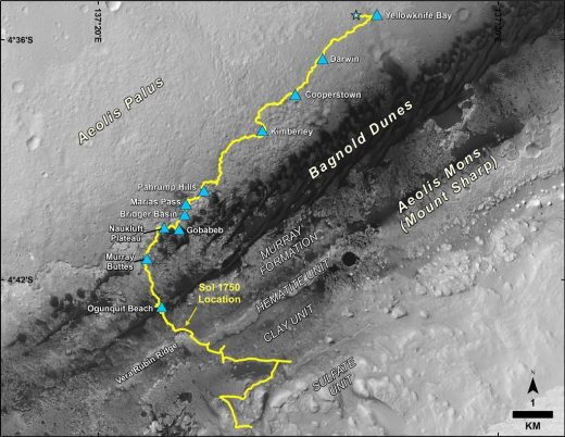
In the five years since Curiosity landed in Gale Crater, it has moved only about 17 km but has done a lot of science along the way: Mid-2017 Map of NASA’s Curiosity Mars Rover Mission | NASA JPL.

This map shows the route driven by NASA’s Curiosity Mars rover, from the location where it landed in August 2012 to its location in July 2017, and its planned path to additional geological layers of lower Mount Sharp.

NASA JPL recently held a public seminar to celebrate Five Years of Curiosity on Mars and to report on what has been learned so far, especially regarding the conditions of the young Red Planet when it appears to have had an atmosphere and large bodies of water on the surface.

Nearly five years after its celebrated arrival at Mars, the Curiosity rover continues to reveal Mars as a once-habitable planet. Early in the planet’s history, generations of streams and lakes created the landforms that Curiosity explores today. The rover currently is climbing through the foothills of Mount Sharp, a 3-mile-high mountain formed from sediment brought in by water and wind. This talk will cover the latest findings from the mission, the challenges of exploration with an aging robot, and what lies ahead.

Speakers:
James K. Erickson, Mars Science Laboratory Project Manager, JPL
Ashwin R. Vasavada, Mars Science Laboratory Project Scientist, JPL

On the left in this image is an artist’s view of how Mars might have looked in its first billion years as compared to earth on the right:

Video: Fly over Pluto and its largest moon Charon

Created from imagery and elevation data from the New Horizon probe‘s fly-by of the Pluto system in July of 2015, the videos below show what it would look like to fly low over Pluto and  its biggest moon Charon:

NASA Video Soars over Pluto’s Majestic Mountains and Icy Plains

In July 2015, NASA’s New Horizons spacecraft sent home the first close-up pictures of Pluto and its moons – amazing imagery that inspired many to wonder what a flight over the distant worlds’ icy terrain might be like.

Wonder no more. Using actual New Horizons data and digital elevation models of Pluto and its largest moon Charon, mission scientists have created flyover movies that offer spectacular new perspectives of the many unusual features that were discovered and which have reshaped our views of the Pluto system – from a vantage point even closer than the spacecraft itself.

This dramatic Pluto flyover begins over the highlands to the southwest of the great expanse of nitrogen ice plain informally named Sputnik Planitia. The viewer first passes over the western margin of Sputnik, where it borders the dark, cratered terrain of Cthulhu Macula, with the blocky mountain ranges located within the plains seen on the right. The tour moves north past the rugged and fractured highlands of Voyager Terra and then turns southward over Pioneer Terra — which exhibits deep and wide pits — before concluding over the bladed terrain of Tartarus Dorsa in the far east of the encounter hemisphere.

The equally exciting flight over Charon begins high over the hemisphere New Horizons saw on its closest approach, then descends over the deep, wide canyon of Serenity Chasma. The view moves north, passing over Dorothy Gale crater and the dark polar hood of Mordor Macula. The flight then turns south, covering the northern terrain of Oz Terra before ending over the relatively flat equatorial plains of Vulcan Planum and the “moated mountains” of Clarke Montes.

The topographic relief is exaggerated by a factor of two to three times in these movies to emphasize topography; the surface colors of Pluto and Charon also have been enhanced to bring out detail.

Digital mapping and rendering were performed by Paul Schenk and John Blackwell of the Lunar and Planetary Institute in Houston. All feature names in the Pluto system are informal.