Category Archives: Space Science

Voyager 2 reaches interstellar space

NASA’s Voyager 2 spacecraft, launched in 1977, joins Voyager 1 in leaving the Sun’s heliosphere and entering interstellar space:

NASA’s Voyager 2 Probe Enters Interstellar Space

For the second time in history, a human-made object has reached the space between the stars. NASA’s Voyager 2 probe now has exited the heliosphere – the protective bubble of particles and magnetic fields created by the Sun.

Members of NASA’s Voyager team will discuss the findings at a news conference at 11 a.m. EST (8 a.m. PST) today at the meeting of the American Geophysical Union (AGU) in Washington. The news conference will stream live on the agency’s website.

Comparing data from different instruments aboard the trailblazing spacecraft, mission scientists determined the probe crossed the outer edge of the heliosphere on Nov. 5. This boundary, called the heliopause, is where the tenuous, hot solar wind meets the cold, dense interstellar medium. Its twin, Voyager 1, crossed this boundary in 2012, but Voyager 2 carries a working instrument that will provide first-of-its-kind observations of the nature of this gateway into interstellar space.

This illustration shows the position of NASA’s Voyager 1 and Voyager 2 probes, outside of the heliosphere, a protective bubble created by the Sun that extends well past the orbit of Pluto. Credits: NASA/JPL-Caltech

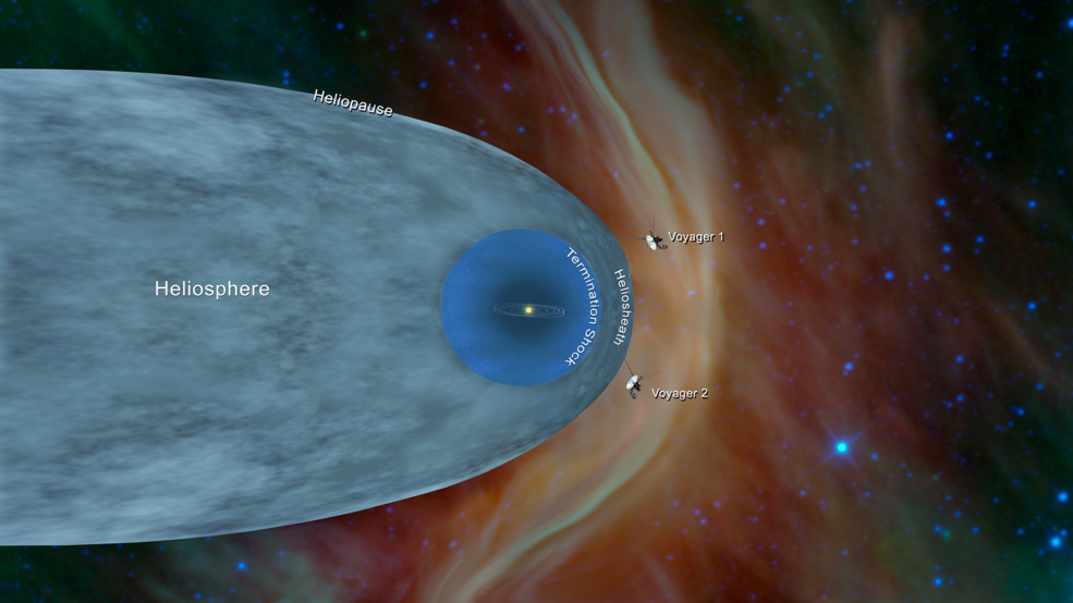
Voyager 2 now is slightly more than 11 billion miles (18 billion kilometers) from Earth. Mission operators still can communicate with Voyager 2 as it enters this new phase of its journey, but information – moving at the speed of light – takes about 16.5 hours to travel from the spacecraft to Earth. By comparison, light traveling from the Sun takes about eight minutes to reach Earth.

The most compelling evidence of Voyager 2’s exit from the heliosphere came from its onboard Plasma Science Experiment (PLS), an instrument that stopped working on Voyager 1 in 1980, long before that probe crossed the heliopause. Until recently, the space surrounding Voyager 2 was filled predominantly with plasma flowing out from our Sun. This outflow, called the solar wind, creates a bubble – the heliosphere – that envelopes the planets in our solar system. The PLS uses the electrical current of the plasma to detect the speed, density, temperature, pressure and flux of the solar wind. The PLS aboard Voyager 2 observed a steep decline in the speed of the solar wind particles on Nov. 5. Since that date, the plasma instrument has observed no solar wind flow in the environment around Voyager 2, which makes mission scientists confident the probe has left the heliosphere.

“Working on Voyager makes me feel like an explorer, because everything we’re seeing is new,” said John Richardson, principal investigator for the PLS instrument and a principal research scientist at the Massachusetts Institute of Technology in Cambridge. “Even though Voyager 1 crossed the heliopause in 2012, it did so at a different place and a different time, and without the PLS data. So we’re still seeing things that no one has seen before.”

In addition to the plasma data, Voyager’s science team members have seen evidence from three other onboard instruments – the cosmic ray subsystem, the low energy charged particle instrument and the magnetometer – that is consistent with the conclusion that Voyager 2 has crossed the heliopause. Voyager’s team members are eager to continue to study the data from these other onboard instruments to get a clearer picture of the environment through which Voyager 2 is traveling.

“There is still a lot to learn about the region of interstellar space immediately beyond the heliopause,” said Ed Stone, Voyager project scientist based at Caltech in Pasadena, California. 

Together, the two Voyagers provide a detailed glimpse of how our heliosphere interacts with the constant interstellar wind flowing from beyond. Their observations complement data from NASA’s Interstellar Boundary Explorer (IBEX), a mission that is remotely sensing that boundary. NASA also is preparing an additional mission – the upcoming Interstellar Mapping and Acceleration Probe (IMAP), due to launch in 2024 – to capitalize on the Voyagers’ observations.

“Voyager has a very special place for us in our heliophysics fleet,” said Nicola Fox, director of the Heliophysics Division at NASA Headquarters. “Our studies start at the Sun and extend out to everything the solar wind touches. To have the Voyagers sending back information about the edge of the Sun’s influence gives us an unprecedented glimpse of truly uncharted territory.”

While the probes have left the heliosphere, Voyager 1 and Voyager 2 have not yet left the solar system, and won’t be leaving anytime soon. The boundary of the solar system is considered to be beyond the outer edge of the Oort Cloud, a collection of small objects that are still under the influence of the Sun’s gravity. The width of the Oort Cloud is not known precisely, but it is estimated to begin at about 1,000 astronomical units (AU) from the Sun and to extend to about 100,000 AU. One AU is the distance from the Sun to Earth. It will take about 300 years for Voyager 2 to reach the inner edge of the Oort Cloud and possibly 30,000 years to fly beyond it.

The Voyager probes are powered using heat from the decay of radioactive material, contained in a device called a radioisotope thermal generator (RTG). The power output of the RTGs diminishes by about four watts per year, which means that various parts of the Voyagers, including the cameras on both spacecraft, have been turned off over time to manage power.

“I think we’re all happy and relieved that the Voyager probes have both operated long enough to make it past this milestone,” said Suzanne Dodd, Voyager project manager at NASA’s Jet Propulsion Laboratory (JPL) in Pasadena, California. “This is what we’ve all been waiting for. Now we’re looking forward to what we’ll be able to learn from having both probes outside the heliopause.”

Voyager 2 launched in 1977, 16 days before Voyager 1, and both have traveled well beyond their original destinations. The spacecraft were built to last five years and conduct close-up studies of Jupiter and Saturn. However, as the mission continued, additional flybys of the two outermost giant planets, Uranus and Neptune, proved possible. As the spacecraft flew across the solar system, remote-control reprogramming was used to endow the Voyagers with greater capabilities than they possessed when they left Earth. Their two-planet mission became a four-planet mission. Their five-year lifespans have stretched to 41 years, making Voyager 2 NASA’s longest running mission.

The Voyager story has impacted not only generations of current and future scientists and engineers, but also Earth’s culture, including film, art and music. Each spacecraft carries a Golden Record of Earth sounds, pictures and messages. Since the spacecraft could last billions of years, these circular time capsules could one day be the only traces of human civilization.

Voyager’s mission controllers communicate with the probes using NASA’s Deep Space Network (DSN), a global system for communicating with interplanetary spacecraft. The DSN consists of three clusters of antennas in Goldstone, California; Madrid, Spain; and Canberra, Australia.

The Voyager Interstellar Mission is a part of NASA’s Heliophysics System Observatory, sponsored by the Heliophysics Division of NASA’s Science Mission Directorate in Washington. JPL built and operates the twin Voyager spacecraft. NASA’s DSN, managed by JPL, is an international network of antennas that supports interplanetary spacecraft missions and radio and radar astronomy observations for the exploration of the solar system and the universe. The network also supports selected Earth-orbiting missions. The Commonwealth Scientific and Industrial Research Organisation, Australia’s national science agency, operates both the Canberra Deep Space Communication Complex, part of the DSN, and the Parkes Observatory, which NASA has been using to downlink data from Voyager 2 since Nov. 8.

For more information about the Voyager mission, visit: https://www.nasa.gov/voyager

More information about NASA’s Heliophysics missions is available online at: https://www.nasa.gov/sunearth

Mars: Insight deploys solar arrays + Cliffs expose ice layers + Successful deep space CubeSat demo

NASA’s Insight lander, which arrived on Mars on Monday, is moving quickly towards operational status. The solar panels have been deployed and in the

… coming days, the mission team will unstow InSight’s robotic arm and use the attached camera to snap photos of the ground so that engineers can decide where to place the spacecraft’s scientific instruments. It will take two to three months before those instruments are fully deployed and sending back data.

In the meantime, InSight will use its weather sensors and magnetometer to take readings from its landing site at Elysium Planitia — its new home on Mars.

More at InSight Is Catching Rays on Mars – NASA JPL.

“The Instrument Deployment Camera (IDC), located on the robotic arm of NASA’s InSight lander, took this picture of the Martian surface on Nov. 26, 2018, the same day the spacecraft touched down on the Red Planet. The camera’s transparent dust cover is still on in this image, to prevent particulates kicked up during landing from settling on the camera’s lens. This image was relayed from InSight to Earth via NASA’s Odyssey spacecraft, currently orbiting Mars.” Credits: NASA/JPL-Caltech. Full image and caption

===

Here’s a report from Bob Zimmerman about the landing: November 27, 2018 Zimmerman/Batchelor podcast | Behind The Black

===

As an aside here, Bob also has an interesting posting about Mars water. While it has been known for many decades that Mars has substantial amounts of water in its surface, much has been learned in recent years about the extent and distribution of that water and much more remains to be discovered. An example of this is the recent finding in Mars orbiter images of layers of water ice exposed on a number of cliffs in the mid-latitudes of the planet:

From the JPL release:

The ice was likely deposited as snow long ago. The deposits are exposed in cross section as relatively pure water ice, capped by a layer one to two yards (or meters) thick of ice-cemented rock and dust. They hold clues about Mars’ climate history. They also may make frozen water more accessible than previously thought to future robotic or human exploration missions.

As Bob notes, such easily accessible water resources will be useful for more than scientific research:

There will come a time when Martian settlers will set up operations here, mining the water for their use. This could very well be extremely valuable real estate on Mars.

“A cross-section of underground ice is exposed at the steep slope that appears bright blue in this enhanced-color view from the HiRISE camera on NASA’s Mars Reconnaissance Orbiter. The scene is about 550 yards wide. The scarp drops about 140 yards from the level ground in the upper third of the image.” Image Credit: NASA/JPL-Caltech/UA/USGS › Full image and caption

===

The CubeSats launched with Insight proved their worth by relaying communications to earth during the lander’s descent and touch down. Furthermore, they have proved the worth of CubeSats for deep space exploration in general, opening up the potential for lower cost and more frequent exploration missions throughout the solar system:

From the NASA JPL release:

Neither of the MarCO CubeSats carry science instruments, but that didn’t stop the team from testing whether future CubeSats could perform useful science at Mars. As MarCO-A flew by, it conducted some impromptu radio science, transmitting signals through the edge of Mars’ atmosphere. Interference from the Martian atmosphere changes the signal when received on Earth, allowing scientists to determine how much atmosphere is present and, to some degree, what it’s made of.

“CubeSats have incredible potential to carry cameras and science instruments out to deep space,” said John Baker, JPL’s program manager for small spacecraft. “They’ll never replace the more capable spacecraft NASA is best known for developing. But they’re low-cost ride-alongs that can allow us to explore in new ways.”

===

Scott Manley gives an overview of the Insight mission:

====

Check out the Best Selling Electronics at Amazon

Videos: Follow the Insight Mission landing on Mars today [Update]

[ Update: The landing was a success: NASA InSight Lander Arrives on Martian Surface | NASA

NASA’s InSight Mars lander acquired this image of the area in front of the lander using its lander-mounted, Instrument Context Camera (ICC). This image was acquired on Nov. 26, 2018, Sol 0 of the InSight mission where the local mean solar time for the image exposures was 13:34:21. Each ICC image has a field of view of 124 x 124 degrees. Credits: NASA/JPL-CalTech

]

NASA’s Insight spacecraft will set down on the Martian surface today Nov. 26th at around noon PST (3 p.m. EST). NASA TV will provide live coverage:

InSight was launched on May 5th and marks the first landing of a NASA spacecraft on the Red Planet since the Curiosity rover arrived in 2012. InSight’s mission, which should last at least two years, is to study Mars’ deep interior. The studies will help scientists better understand the formation of Mars as well as other rocky worlds, including Earth.

InSight is accompanied by two mini-spacecraft in a test named Mars Cube One (MarCO). This is the first deep-space mission for CubeSats. The MarCO satellites will not land but instead will fly by Mars and attempt to relay data from InSight during its entry into the planet’s atmosphere and the landing sequence.

For the key events during the landing, see NASA InSight Landing on Mars: Milestones | NASA.

Here is a preview of the Insight landing:

NASA’s Mars Interior Exploration using Seismic Investigations, Geodesy and Heat Transport (InSight) spacecraft is on track for a touchdown on the surface of the Red Planet on Nov. 26. One day before landing, the mission team provides an update and explanations of everything that must go right during the entry, descent and landing of the spacecraft. 

And here is a Q&A with the Insight mission team:

====

Telescopes and Binoculars at Amazon

Mars: Insight news conferences + Mars 2020 landing target + Soft landslides

NASA TV will webcast two programs today about the upcoming touch down of the Insight lander on Mars: NASA Live: InSight Mars Landing | NASA 

NASA’s InSight lander is scheduled to touch down on Mars at approximately 3 p.m. EST, Monday, Nov. 26. NASA TV live coverage of the InSight Mars landing will begin at 2 p.m. Eastern (7 p.m. UTC). Upcoming briefings:

Wednesday, Nov. 21, 1 p.m. EST: InSight Mars Lander news conference: Mission engineering overview.
Wednesday, Nov. 21, 2 p.m. EST: InSight Mars Lander news conference: Mission science overview

It will take about 8 minutes for signals from Insight to reach earth during its descent through the atmosphere and the touch down on the surface. Here’s an item about the communications systems that allow for ground controllers to know what happened : How NASA Will Know When InSight Touches Down – NASA JPL


Insight landing sequence: Credits: Emily Lakdawalla for The Planetary Society

===

The Mars 2020 Rover, which is similar in design and capabilities to the Curiosity rover, now knows where it will land: NASA Announces Landing Site for Mars 2020 Rover – NASA JPL

This Mars map depicts the final four locations under consideration for the landing site of Mars 2020. The topographic map of Mars was created by the Mars Orbital Laser Altimeter (MOLA) on board the robot Mars Global Surveyor spacecraft. MOLA measured heights on Mars by precisely determining the time it took for a low power laser beam to bounce off the surface. Image Credit: NASA/MGS/MOLA Science Team. Larger view

Speaking of Curiosity, here is a recent update on its activities: Curiosity on the Move Again | NASA.

===

Bob Zimmerman examines an image taken of the Martian surface and highlights what is similar and different between geologic processes on Mars versus on the Earth: The soft landslides of Mars | Behind The Black

The light gravity of Mars, combined with different materials, a lot of dust, and a geological history different from Earth, produces events that — though reminiscent of similar geological events on Earth — are definitely not the same.

Landslide in Southern Mid-Latitude Crater – HiRISE

====

Telescopes and Binoculars at Amazon

New images and video from Juno at Jupiter

More cool views of Jupiter via Juno images enhanced by citizen scientists:

** Jupiter in the Rearview Mirror | Mission Juno

In the final minutes of a recent close flyby of Jupiter, NASA’s Juno spacecraft captured a departing view of the planet’s swirling southern hemisphere. This color-enhanced image was taken at 7:13 p.m. PDT on Sept. 6, 2018 (10:13 p.m. EDT) as the spacecraft performed its 15th close flyby of Jupiter. At the time, Juno was about 55,600 miles (89,500 kilometers) from the planet’s cloud tops, above a southern latitude of approximately 75 degrees.  Citizen scientist Gerald Eichstädt created this image using data from the spacecraft’s JunoCam imager. Image Credits: NASA/JPL-Caltech/SwRI/MSSS/Gerald Eichstädt

** Juno’s Perijove-15 Jupiter Flyby, Reconstructed in 125-Fold Time-LapseGerald Eichstädt

From the caption:

Early on September 07, 2018, UTC, NASA’s Juno probe successfully performed her Perijove-15 Jupiter flyby. Like during most of the recent Jupiter flybys, good contact to Earth and incremented storage allowed taking close-up images of good quality.

The movie is a reconstruction of the 112 minutes between 2018-09-07T00:30:00.000 and 2018-09-07T02:22:00.000 in 125-fold time-lapse.
It is based on 25 of the JunoCam images taken, and on spacecraft trajectory data provided via SPICE kernel files.

In steps of five real-time seconds, one still images of the movie has been rendered from at least one suitable raw image. This resulted in short scenes, usually of a few seconds. Playing with 25 images per second results in 125-fold time-lapse.

** Let Me See What Spring Is Like On Jupiter And MarsMoshe16

====

Chasing New Horizons: Inside the Epic First Mission to Pluto