Category Archives: Space Science

New book on using the Mini-Cube for STEM now in paperback

I’ve posted here many times about JP Aerospace, which has been flying high altitude balloons and airships for over 30 years. Founded and led by John Powell, the part professional, part volunteer organization has won USAF contracts, carried out multiple promotional flights for companies from around the world, and developed a number of innovations in the technology of Near Space.

Furthermore, JPA has a very active education program. Over 50,000 students have had their PongSats taken to the edge of space for free by JPA.

FourPongSatsOn2014FlightFour PongSats mounted on a JPA balloon structure
during a high-altitude flight in October 2014.

A PongSat is a ping-pong ball with a tiny experiment inside of it. A few years ago, JPA introduced the Mini-Cube, which provides a standardize plastic box structure, 5 cm to a side, in which more sophisticated and elaborate experiments can be enclosed and flown for a fee to Near Space.

minicubebanner[1]

Back in May I posted about an ebook written by Gregory N. Cecil that provides a step-by-step tutorials for teachers, students, and anyone else on how use a Mini-Cube for low-cost educational Near Space experiments and demonstrations. The book is now available in paperback: Classroom Laboratory at the Edge of Space: Introducing the Mini-Cube Program.

A book written for secondary public and private school STEM instructors, home schooling, and undergraduate STEM courses of study explaining how to set up their own student focused “space program” utilizing the Mini-Cube Program. With this Informal STEM Project Based Learning Activity, students can have the unique, affordable, and challenging opportunity to send experiments via high altitude balloon to an altitude of 100,000 feet (20 miles or 32 km), commonly known as the “edge of space.” Utilizing the scientific method, team work, research, and communicating in writing the results and applications for peer review, students will participate in the full cycle of an actual experiment from the original question to the published results and conduct true science at the edge of space.

Utilizing the scientific method, team work, research, and communicating in writing the results and applications for peer review, students will participate in the full cycle of an actual experiment from the original question to the published results and conduct true science at the edge of space.

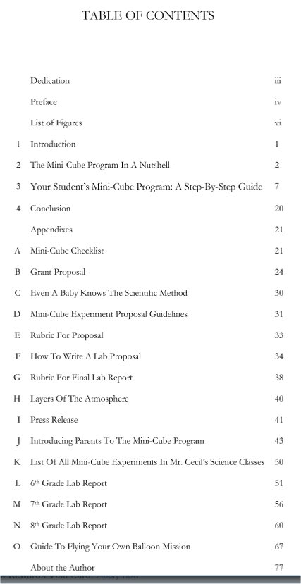
Here is the table of contents for the book:

BookTOC


New Horizons: Images & fly-over video of Pluto’s moon Charon show a dramatic landscape

The New Horizons missions releases great imagery of Pluto’s moon Charon:

Pluto’s Big Moon Charon Reveals a Colorful and Violent History

NASA’s New Horizons spacecraft has returned the best color and the highest resolution images yet of Pluto’s largest moon, Charon – and these pictures show a surprisingly complex and violent history.

Charon-Neutral-Bright-Release[1]
Charon in Enhanced Color: NASA’s New Horizons captured this high-resolution enhanced color view of Charon just before closest approach on July 14, 2015. The colors are processed to best highlight the variation of Charon’s surface properties. (Larger image)
At half the diameter of Pluto, Charon is the largest satellite relative to its planet in the solar system. Many New Horizons scientists expected Charon to be a monotonous, crater-battered world; instead, they’re finding a landscape covered with mountains, canyons, landslides, surface-color variations and more.

“We thought the probability of seeing such interesting features on this satellite of a world at the far edge of our solar system was low,” said Ross Beyer, an affiliate of the New Horizons Geology, Geophysics and Imaging (GGI) team from the SETI Institute and NASA Ames Research Center in Mountain View, California, “but I couldn’t be more delighted with what we see!”

Charon-Detail-(with-connecting-lines)-9-29-15[1]
Charon in Detail: Charon’s cratered uplands at the top are broken by series of canyons, and replaced on the bottom by the rolling plains of the informally named Vulcan Planum. (Larger image.)
High-resolution images of the Pluto-facing hemisphere of Charon, taken by New Horizons as the spacecraft sped through the Pluto system on July 14, and transmitted to Earth on Sept. 21, reveal details of a belt of fractures and canyons just north of the moon’s equator. This great canyon system stretches across the entire face of Charon, more than a thousand miles, and probably around onto Charon’s far side. Four times as long as the Grand Canyon, and twice as deep in places, these faults and canyons indicate a titanic geological upheaval in Charon’s past.

Pluto-Charon-v2-10-1-15[1]
Strikingly Different Worlds: A composite of enhanced color images highlights the striking differences between Pluto and Charon. (Larger image)
“It looks like the entire crust of Charon has been split open,” said John Spencer, deputy lead for GGI at the Southwest Research Institute in Boulder, Colorado. “In respect to its size relative to Charon, this feature is much like the vast Valles Marineris canyon system on Mars.”

The team has also discovered that the plains south of the canyon, informally referred to as Vulcan Planum, have fewer large craters than the regions to the north, indicating that they are noticeably younger. The smoothness of the plains, as well as their grooves and faint ridges, are clear signs of wide-scale resurfacing.

One possibility for the smooth surface is a kind of cold volcanic activity, called cryovolcanism. “The team is discussing the possibility that an internal water ocean could have frozen long ago, and the resulting volume change could have led to Charon cracking open, allowing water-based lavas to reach the surface at that time,” said Paul Schenk, a New Horizons team member from the Lunar and Planetary Institute in Houston.

Even higher-resolution Charon images and composition data are still to come as New Horizons transmits data, stored on its digital recorders, over the next year – and as that happens, “I predict Charon’s story will become even more amazing!” said mission Project Scientist Hal Weaver, of the Johns Hopkins University Applied Physics Laboratory in Laurel, Maryland.

The New Horizons spacecraft is currently 3.1 billion miles (5 billion kilometers) from Earth, with all systems healthy and operating normally.

New Horizons is part of NASA’s New Frontiers Program, managed by the agency’s Marshall Space Flight Center in Huntsville, Alabama. APL designed, built, and operates the New Horizons spacecraft and manages the mission for NASA’s Science Mission Directorate. SwRI leads the science mission, payload operations, and encounter science planning.

Video: ESA AIM will watch NASA DART smack into an asteroid

An earlier post described the European Space Agency’s Asteroid Impact Mission (AIM), which in 2020 will send a probe to the Didymos binary asteroid system. AIM will initially “perform high-resolution visual, thermal and radar mapping of the moon”, i.e. the smaller of the two asteroids, “to build detailed maps of its surface and interior structure”.

AIDA_mission_concept_node_full_image_2[1]

Two years later, NASA’s DART (Double Asteroid Redirection Test) spacecraft will reach Didymos and collide into the moon while observed by AIM. The goal is to measure the amount of deflection of the asteroid and record the effects of the collision on the surface structure of the asteroid. This joint mission is called the Asteroid Impact & Deflection Assessment (AIDA) study.

Here is a video about the AIM plan:

Lunar Mission One and Astrobotic will take put your “Footsteps on the Moon”

Lunar Mission One is a non-profit organization seeking to raise public funding for space science projects. Their primary space science goal is to put a robotic spacecraft on the south pole of the Moon in 2024 to investigate water and other resources there. A Kickstarter campaign in 2014 raised over $1M.

They have a number of public involvement initiatives programs underway. This week, for example, they opened the Footsteps on the Moon campaign in which you upload “a photo of your footprints, feet or shoes” that will be sent to the Moon on digital storage.

CQI0rVFUEAATLiy[1]

The transport to the Moon will be via Astrobotic‘s lunar lander mission: Lunar Mission One Signs Deal with Astrobotic

Astrobotic Technology Inc. and Lunar Missions Ltd, the company behind the global, inclusive, not-for- profit crowd-funded Lunar Mission One, have signed a deal to send the first digital storage payload to the Moon. The payload will support Lunar Mission One’s ‘Footsteps on the Moon’ campaign, launched earlier today, which invites millions of people to include their footsteps – in addition to images, video and music – in a digital archive of human life that will be placed on the moon during Astrobotic’s first lunar mission.

“The partnership with Lunar Mission One is an exciting opportunity for individuals to store memorable information on the surface of the Moon,” says John Thornton, CEO of Astrobotic. “This is the first step in creating an archive of human civilization beyond Earth orbit.”

David Iron, CEO of Lunar Missions Ltd and the founder of Lunar Mission One says, “It was an easy choice to partner with Astrobotic, a global leader in commercial lunar capability. This deal allows us to offer an exciting new way to connect our supporters to the Moon during the early phase of Lunar Mission One’s development. We look forward to unveiling those plans very soon.”

Lunar Mission One is the latest addition to Astrobotic’s mission one manifest, and will be the first payload to enable a digital archive on the Moon.

David Iron, the founder of Lunar Mission One, writes the organization and the Footsteps program: Lunar Mission One: “Let’s All Stand on the Moon Together” – David Iron/Huffington Post

Most people watching the Moon landings in 1969 thought they would never make it to the Moon… but it’s time for a re-think. The astronauts left their prints and the rest of us just dreamed, but Lunar Mission One now intends to make it possible with their Footsteps on the Moon project.

We have secured a digital payload on the Astrobotic Moon Lander, slated for a 2017 launch. On it, we want to take a vast collection of pictures of your footsteps, shoes, wheelchair tracks or however you leave your impression on the Earth, and place them on the Moon. And we will do that for nothing in the hopes that we can take images from every single country on Earth.

In digital form, your footsteps will rest on the Moon, like the iconic boot prints left by the first astronauts, almost 50 years ago.

Follow the latest LMO activities at Lunar Mission One (@LunarMissionOne) | Twitter.

Video: Perchlorate salts and the availability of water on Mars

In this brief video,

Doug Archer, Planetary Scientist at NASA Johnson Space Center, talks about perchlorate salts, a compound that absorbs water on Mars. Archer addresses how perchlorate can serve as a valuable resource for human exploration missions to Mars in the future.