Urban Astronomer hosts the latest Carnival of Space.
Carnival of Space #317 – Urban Astronomer
Urban Astronomer hosts the latest Carnival of Space.
Urban Astronomer hosts the latest Carnival of Space.
“Legendary” Chris Kraft, the first NASA manned spaceflight director, lays into the SLS mess again: Sunday conversation: NASA veteran Chris Kraft upfront with criticism – Houston Chronicle
A sampling of his comments:
These are all common sense remarks that many critics of the SLS/Orion program have been saying since it was hatched in 2010 by a cabal of Congresspersons with NASA centers and/or major NASA contractors in their states (i.e. the only people in Congress who pay attention to space policy). Unfortunately, the program remains a gigantic money-burning fiasco hidden in plain sight because the MSM can’t judge a technical issue like space launch and so few high profile space luminaries point out what a bare-naked boondoggle it is.
More space policy related items:
Update: Scott Pace of GWU talked about space policy on the Space Show yesterday: Dr. Scott Pace, Sunday, 9-1-13 – Thespaceshow’s Blog
Here’s a great collection of satellite images of islands: Islands from the air: Stunning photographs taken from space show Earth’s archipelagos as you’ve never seen them before – Mail Online. (Note that the images were not made “from thousands of miles away” but typically from satellites circling the earth orbit at at around 400 miles (700km) above the earth’s surface.
![ISS013-E-28610_lrg[1]](http://hobbyspace.com/Blog/wp-content/uploads/2013/09/ISS013-E-28610_lrg1.jpg) Nukuoro Atoll, Federated States of Micronesia
Nukuoro Atoll, Federated States of Micronesia
Another of the images in the collection is of the Palm Jumeirah man-made island in Dubai:
![dubai_20110425[1]](http://hobbyspace.com/Blog/wp-content/uploads/2013/09/dubai_201104251-300x200.jpg)
Here is a series of images showing the island during its construction: World of Change: Urbanization of Dubai.
===
Here’s a very different kind of example of satellite imaging applications: Satellite images show North Korea expanding rocket launch site, analysts say – Fox News
In the HobbySpace Radio section I describe a weather satellite image receiving station I set up many years ago consisting of a simple antenna, a PC controllable receiver and a PC with a sound card. When a satellite passed overhead, and the receiver was set to the proper frequency band, the sound card would digitize the receiver output and programs running on the PC would convert this data into an image. (I also had a program running to track satellites to know when a low earth orbit weathersat would be in range.)
 A LEO weather satellite image (Colors assigned to gray scale values.)
That was a fairly inexpensive station but now there are even cheaper ways to do weathersat imaging at home.
A few times I’ve mentioned the FUNcube Dongle project that was created as part of the UK FUNcube satellite project to get students and the general public involved in receiving signals from that satellite. The FUNcube Dongle is based on Software-defined radio (SDR).
SDR uses the power of modern microprocessors to allow a software program to replace many of the tasks previously done in a hardware receiver to isolate and process and demodulate a signal of interest in a particular frequency band. The software works on data obtained from digitizing the raw electromagnetic wave patterns from an antenna.
Ideally an antenna output would straight into an analog to digital converter (ADC) in the PC, such as that available in the sound card, and the SDR program would work on the ADC output. However, that is not practical with real world noisy, weak signals. So some interface hardware is still needed. This can be provided by a “dongle” USB device that might include a low noise amplifier, a tuner to obain signals in a given frequency range, a ADC, plus a processor to control all this and talk with the PC. The output of the dongle is then used by the SDR program running on the PC.

From Introduction to the FUNcube Dongle (pdf)
So a system to receive low earth orbit weather satellite images can now be as simple as an antenna connected to a small low cost dongle plugged into the USB port of a computer running the SDR program. which analyzes the digitized signal in the frequency range selected by the user. For satellite imaging, there would, as with the standard hardware tuner case, be another program to decode the signal into a weather image.
Besides the FUNcube Dongle, the company NooElec offers kits with an antenna and a SDR dongle. (Available at Amazon: Terratec DVB-T USB Receiver & Low-Cost Software Defined Radio (SDR)
A free program to operate such systems is available at SDR-RADIO.com. Here is a tutorial for using it to pick up weather satellite images: Software Defined Radio for Mariners: Weather Satellites.
Find more SDR resources here.
The signal environment where you are located, say in the middle of a city with high buildings, could be very poor for satellite reception. In that case, you can still do SDR satellite reception by getting the signal data from other locations via the web. See SDRSPACE.com for details.
The latest presentation to the Future In-Space Operations (FISO) study group is now posted in the FISO Working Group Presentations Archive. Both slides (pptx) and audio (mp3) are available for the talk, Target NEO2: Workshop Summary and Next Steps – Rich Dissly , Ball Aerospace – August 28, 2013
This is quite an interesting overview and summary of the Target NEO workshop held back in July on the proposed NASA mission to move a small asteroid to the Earth-Moon system using an unmanned spacecraft and then do close-up examinations with astronaut missions to it. You can find the individual presentation files here and the executive summary here.
Note that the program is referred in some places as ARRM (Asteroid Robotic Redirect Mission) and other places as ARM (Asteroid Redirect Mission).
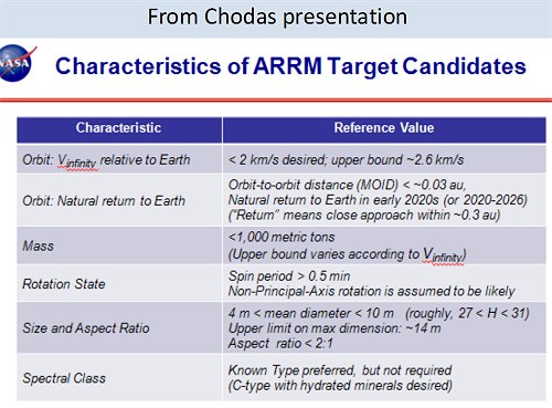
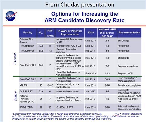
There is a lot of discussion about improving the search for Goldilocks objects, e.g.:
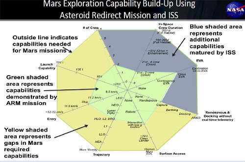
There’s probably a good amount of sci-fi in it but I like this multi-dimensional graph from NASA’s Bill Gerstenmaier illustrating the various technological capabilities needed for a Mars crew mission and where asteroid missions and ISS activities contribute to those capabilities:
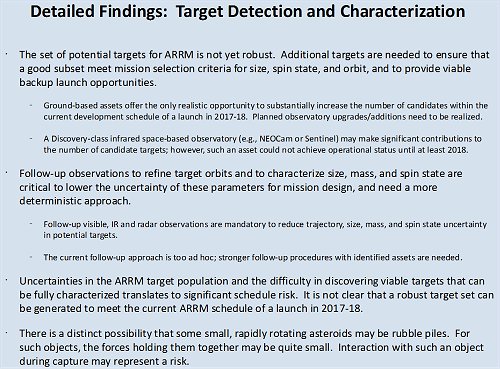
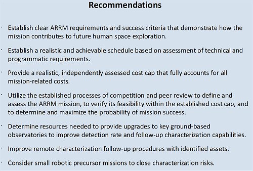
Finding an ideal asteroid target is very difficult and may take longer than the current mission time scale allows: