Category Archives: Multiple media

Juno: The chaotic clouds of Jupiter

These processed images of Jupiter from the Juno probe never get old. Here is a new one:

Chaotic Clouds of Jupiter

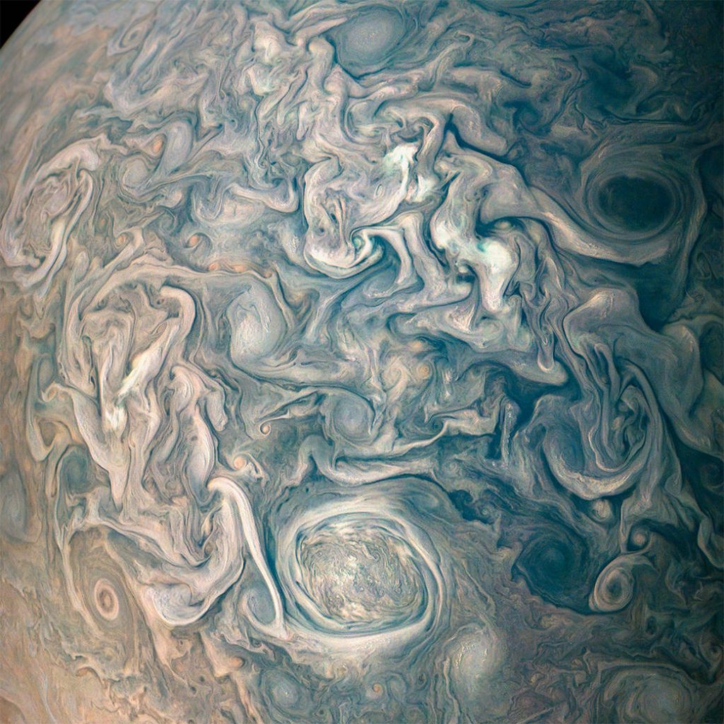
This image captures swirling cloud belts and tumultuous vortices within Jupiter’s northern hemisphere.

NASA’s Juno spacecraft took this color-enhanced image at 10:23 p.m. PDT on May 23, 2018 (1:23 a.m. EDT on May 24), as the spacecraft performed its 13th close flyby of Jupiter. At the time, Juno was about 9,600 miles (15,500 kilometers) from the planet’s cloud tops, above a northern latitude of 56 degrees.

The region seen here is somewhat chaotic and turbulent, given the various swirling cloud formations. In general, the darker cloud material is deeper in Jupiter’s atmosphere, while bright cloud material is high. The bright clouds are most likely ammonia or ammonia and water, mixed with a sprinkling of unknown chemical ingredients.

A bright oval at bottom center stands out in the scene. This feature appears uniformly white in ground-based telescope observations. However, with JunoCam we can observe the fine-scale structure within this weather system, including additional structures within it. There is not significant motion apparent in the interior of this feature; like the Great Red Spot, its winds probably slows down greatly toward the center.

Citizen scientists Gerald Eichstädt and Seán Doran created this image using data from the spacecraft’s JunoCam imager.

JunoCam’s raw images are available for the public to peruse and process into image products at www.missionjuno.swri.edu/junocam

More information about Juno is at: https://www.nasa.gov/juno and http://missionjuno.swri.edu

Image Credits: NASA/JPL-Caltech/SwRI/MSSS/Gerald Eichstädt /Seán Doran

===

Dark and Stormy Jupiter

This image captures the intensity of the jets and vortices in Jupiter’s North North Temperate Belt.

NASA’s Juno spacecraft took this color-enhanced image at 10:31 p.m. PDT on May 23, 2018 (1:31 a.m. EDT on May 24), as Juno performed its 13th close flyby of Jupiter. At the time, the spacecraft was about 4,900 miles (7,900 kilometers) from the tops of the clouds of the gas giant planet at a northern latitude of about 41 degrees. The view is oriented with south on Jupiter toward upper left and north toward lower right.

The North North Temperate Belt is the prominent reddish-orange band left of center. It rotates in the same direction as the planet and is predominantly cyclonic, which in the northern hemisphere means its features spin in a counter-clockwise direction. Within the belt are two gray-colored anticyclones.

To the left of the belt is a brighter band (the North North Temperate Zone) with high clouds whose vertical relief is accentuated by the low angle of sunlight near the terminator. These clouds are likely made of ammonia-ice crystals, or possibly a combination of ammonia ice and water. Although the region as a whole appears chaotic, there is an alternating pattern of rotating, lighter-colored features on the zone’s north and south sides.

Scientists think the large-scale dark regions are places where the clouds are deeper, based on infrared observations made at the same time by Juno’s JIRAM experiment and Earth-based supporting observations. Those observations show warmer, and thus deeper, thermal emission from these regions.

To the right of the bright zone, and farther north on the planet, Jupiter’s striking banded structure becomes less evident and a region of individual cyclones can be seen, interspersed with smaller, darker anticyclones.

Citizen scientist Kevin M. Gill created this image using data from the spacecraft’s JunoCam imager.

JunoCam’s raw images are available for the public to peruse and process into image products at: www.missionjuno.swri.edu/junocam

More information about Juno is at: https://www.nasa.gov/juno and http://missionjuno.swri.edu

Image Credits: NASA/JPL-Caltech/SwRI/MSSS/Kevin M. Gill

Image download options

====


Video: Live streaming of ISS camera views of the earth

NASA offers live Youtube streaming of camera views of the earth from the International Space Station:

Behold, the Earth! These are live Earth views from the International Space Station from the High Definition Earth Viewing (HDEV) experiment. While the experiment is operational, views will typically sequence through the different cameras. If you are seeing a black image, the Space Station is on the night side of the Earth. If you are seeing an image with text displayed, the communications are switching between satellites and camera feeds are temporarily unavailable. Between camera switches, a black & gray slate will also briefly appear. 

More from the caption:

The experiment was activated on April 30, 2014 and is mounted on the External Payload Facility of the European Space Agency’s Columbus module. This experiment includes several commercial HD video cameras aimed at the Earth which are enclosed in a pressurized and temperature controlled housing. To learn more about the HDEV experiment, visit: https://eol.jsc.nasa.gov/ESRS/HDEV/

Please note: The HDEV cycling of the cameras will sometimes be halted, causing the video to only show select camera feeds. This is handled by the HDEV team, and is only scheduled on a temporary basis. Nominal video will resume once the team has finished their scheduled event.

====

Video: The phases of the Moon in 2018

A cool video from NASA showing the phases of the Moon for every hour throughout 2018:

This 4K visualization shows the Moon’s phase and libration at hourly intervals throughout 2018, as viewed from the Northern Hemisphere. Two ‘supermoons’ will ring in the New Year on Jan. 1, 2018 and Jan. 31, 2018.

Each frame represents one hour. In addition, this visualization shows the moon’s orbit position, sub-Earth and subsolar points, distance from the Earth at true scale, and labels of craters near the terminator.

More from the caption:

Southern hemisphere version: https://www.youtube.com/watch?v=zv6zm…

Credit: NASA’s Goddard Space Flight Center/David Ladd (USRA)

Ernie Wright (USRA): Lead Visualizer
John Keller (NASA/GSFC): Scientist
Noah Petro (NASA/GSFC): Scientist

Music Credits: Killer Tracks: “Illuminating” – Kelly McCollough. “Touching Clouds” – Kelly Mccullough.

This video is public domain and along with other supporting visualizations can be downloaded from the Scientific Visualization Studio at: https://svs.gsfc.nasa.gov/4604

Waxing gibbous. Visible to the southeast in early evening, up for most of the night. NASA Scientific Visualization Studio.

====

Videos: Top ISS earth images of 2017 and other space sights

Some space eye candy:

** Top 17 Earth Images of 2017 taken by crew members of the International Space Station:

** The Earth: 4k Extended Edition with soundtrack.

** Colorful water in microgravity

** A review of the Juno mission at Jupiter:

** The SpaceX Falcon 9 Iridium 4 launch with music

====

Videos: SpaceX Falcon 9 launch makes for awesome light show over SoCal

A SpaceX Falcon 9 rocket successfully placed 10 Iridium satellites into polar orbits on Saturday evening from Vandenberg AFB in California. The launch produced an amazing light show visible over much of Southern California.

Note that the second light spot visible in the plume is the first stage making a controlled descent. This previously flown booster did not land on a sea-going platform but did otherwise follow a landing style return. SpaceX has run out of storage space for this generation of boosters, which will only be re-flown once. A new version will be introduced in a few months that can be flown a dozen times with only inspection between flights and many more with some refurbishment.

Update: In this view, the two clam shell-like fairings around the satellites can be seen after they separate from the rocket. SpaceX has been developing ways to fly back and recover the fairings. In the video, firings of the cold-gas thrusters on the fairings can be seen:

====