Category Archives: Mars

Space sciences roundup – June.26.2019

A sampling of recent articles, videos, and images from space-related science news items:

Asteroids:

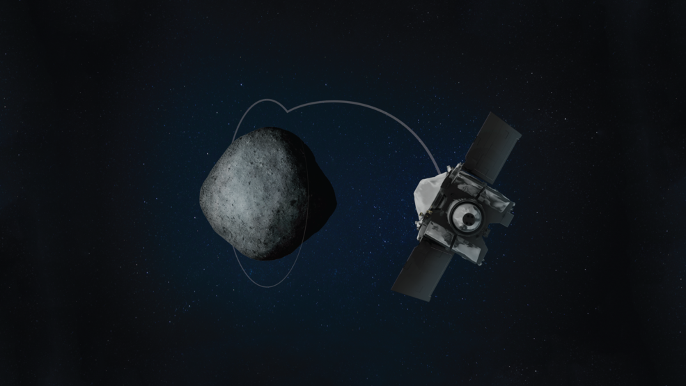
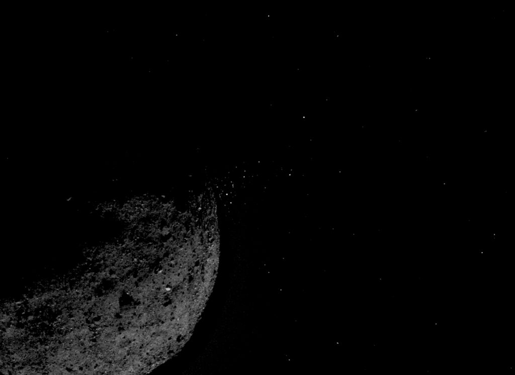
** NASA’s OSIRIS-REx probe gets up close to asteroid Bennu : OSIRIS-REx Breaks Another Orbit Record | NASA

On June 12, NASA’s OSIRIS-REx spacecraft performed another significant navigation maneuver—breaking its own world record for the closest orbit of a planetary body by a spacecraft.

The maneuver began the mission’s new phase, known as Orbital B, and placed the spacecraft in an orbit 680 meters (2,231 feet) above the surface of asteroid Bennu. The previous record—also set by the OSIRIS-REx spacecraft—was approximately 1.3 kilometers (0.8 miles) above the surface.

Upon arrival at Bennu, the team observed particles ejecting into space from the asteroid’s surface. To better understand why this is occurring, the first two weeks of Orbital B will be devoted to observing these events by taking frequent images of the asteroid’s horizon. For the remaining five weeks, the spacecraft will map the entire asteroid using most of its onboard science instruments: the OSIRIS-REx Laser Altimeter (OLA) will produce a full terrain map; PolyCam will form a high-resolution, global image mosaic; and the OSIRIS-REx Thermal Emission Spectrometer (OTES) and the REgolith X-ray Imaging Spectrometer (REXIS) will produce global maps in the infrared and X-ray bands. All of these measurements are essential for selecting the best sample collection site on Bennu’s surface.

Data from these surface studies will be used to find the optimum spot to set down and take a sample to take back to Earth.

The OSIRIS-REx spacecraft is on a seven-year journey to study the asteroid Bennu and return a sample from its surface to Earth. This sample of a primitive asteroid will help scientists understand the formation of the Solar System over 4.5 billion years ago. Sample collection is scheduled for summer of 2020, and the spacecraft will deliver the sample to Earth in September 2023.

An artist's view of OSIRIS-REx investigating asteroid Bennu
“On Jun. 12, 2019, NASA’s OSIRIS-REx spacecraft went into orbit around asteroid Bennu for a second time — breaking its own record for the closest orbit of a planetary body by any spacecraft.” Artwork credits: University of Arizona

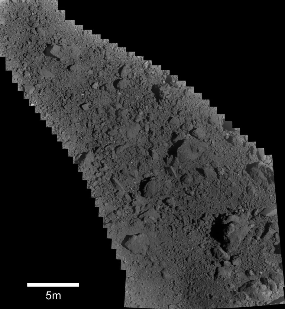
** Japan’s Hayabusa2 probe may touch down on asteroid Ryugu again: Approach to the 2nd touchdown – Part 1: observations near the touchdown point – JAXA Hayabusa2 project

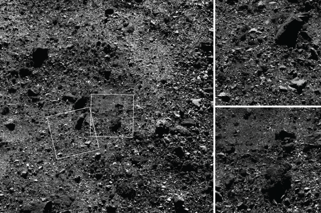
Our first touchdown took place this year on February 22. Then as a new challenge for the Hayabusa2 Project, we succeeded in creating an artificial crater using the Small Carry-on Impactor (SCI) on April 5. The last big operation left at asteroid Ryugu is the collection of subsurface material exposed with the creation of the artificial crater. In order to collect this material, we need a second touchdown for which the project has been steadily preparing. At this point, it has not yet been decided whether or not to go ahead with a second touchdown, but here we will introduce our preparations in the “Approach to the second touchdown”.

After the operation to form the artificial crater, the spacecraft descended a total of four times above or near the crater site. These descent operations allowed us to obtain detailed data of the region near the artificial crater. In addition, we succeeded in dropping a target marker in the area close to the artificial crater on May 30. Combined, these operations mean that the situation around the artificial crater is now well understood.

The rocky surface, however, makes it difficult to find a safe spot to set down.

As you can see in [the figure below], asteroid Ryugu is covered with boulders. If we go for a second touchdown, we need to aim for a point close to the target marker which has no obstacles. The project is currently examining this area in detail.

Image of Ryugu surface
“Image taken on June 13, 2019 during the operation PPTD-TM1B. This is a composite of 28 images taken at 7 second intervals starting from 10:58 JST (upper left) to 11:01 (lower right) using the Optical Navigation Camera – Telescopic (ONC-T). The image altitude is about 52m at the start and 108m at the end. The white point in the upper-left center is the target marker. You can see that detailed images have been acquired continuously from the target marker to the edge of the artificial crater, located in the lower-right of the image. (Image credit ※: JAXA, Chiba Institute of Technology, University of Tokyo, Kochi University, Rikkyo University, Nagoya University, Meiji University, University of Aizu, AIST.) “

The Sun:

** Lunar regolith reveals secrets of the early sun: Moon Samples Help Scientists Study Ancient Sun | NASA

Saxena incorporated the mathematical relationship between a star’s rotation rate and its flare activity. This insight was derived by scientists who studied the activity of thousands of stars discovered by NASA’s Kepler space telescope: The faster a star spins, they found, the more violent its ejections. “As you learn about other stars and planets, especially stars like our Sun, you start to get a bigger picture of how the Sun evolved over time,” Saxena said.  

Using sophisticated computer models, Saxena, Killen and colleagues think they may have finally solved both mysteries. Their computer simulations, which they described on May 3 in the The Astrophysical Journal Letters, show that the early Sun rotated slower than 50% of baby stars. According to their estimates, within its first billion years, the Sun took at least 9 to 10 days to complete one rotation.  

They determined this by simulating the evolution of our solar system under a slow, medium, and then a fast-rotating star. And they found that just one version — the slow-rotating star — was able to blast the right amount of charged particles into the Moon’s surface to knock enough sodium and potassium into space over time to leave the amounts we see in Moon rocks today.   

“Space weather was probably one of the major influences for how all the planets of the solar system evolved,” Saxena said, “so any study of habitability of planets needs to consider it.” 

Jupiter:

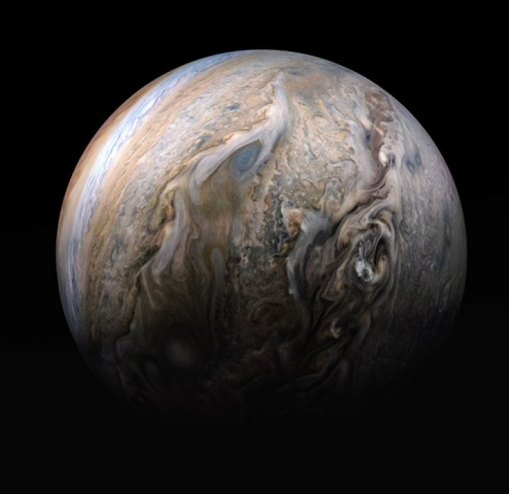
**  More wonderful views of Jupiter created by citizen scientists from Juno’s raw imagery: Tumultuous Clouds of Jupiter | Mission Juno/Kevin M. Gill

This stunning compilation image of Jupiter’s stormy northern hemisphere was captured by NASA’s Juno spacecraft as it performed a close pass of the gas giant planet. Some bright-white clouds can be seen popping up to high altitudes on the right side of Jupiter’s disk. (The Juno team frequently refers to clouds like these as “pop-up” clouds in image captions.)

Juno took the four images used to produce this color-enhanced view on May 29, 2019, between 12:52 a.m. PDT (3:52 a.m. EDT) and 1:03 a.m. PDT (4:03 a.m. EDT), as the spacecraft performed its 20th science pass of Jupiter. At the time the images were taken, the spacecraft was between 11,600 miles (18,600 kilometers) and 5,400 miles (8,600 kilometers) above Jupiter’s cloud tops, above a northern latitude spanning from about 59 to 34 degrees.

Citizen scientist Kevin M. Gill created this image using data from the spacecraft’s JunoCam imager.

Tumultuous Clouds of Jupiter
“Tumultuous Clouds of Jupiter” – Credits NASA/JPL-Caltech/SwRI/MSSS with image processing by Kevin M. Gill.

Gill also made this overflight of Jupiter’s Great Red Spot:

And Gerald Eichstädt made this terrific time-lapsed tour of Jupiter: Juno’s Perijove-20 Jupiter Flyby, Reconstructed in 125-Fold Time-Lapse – Credit: NASA / JPL / SwRI / MSSS / SPICE / Gerald Eichstädt ©

On May 29, 2019, NASA’s Juno probe successfully performed her Perijove-20 Jupiter flyby. The movie is a reconstruction of the 2 hours and 30 minutes between 2019-05-29T07:20:00.000 and 2019-05-29T09:50:00.000 in 125-fold time-lapse. It is based on 32 of the JunoCam images taken, and on spacecraft trajectory data provided via SPICE kernel files.

In steps of five real-time seconds, one still images of the movie has been rendered from at least one suitable raw image. This resulted in short scenes, usually of a few seconds. Playing with 25 images per second results in 125-fold time-lapse. Resulting overlapping scenes have been blended using the ffmpeg tool. In natural colors, Jupiter looks pretty pale. Therefore, the still images are approximately illumination-adusted, i.e. almost flattened, and consecutively gamma-stretched to the 4th power of radiometric values, in order to enhance contrast and color.

Mars:

** Curiosity detects a curious burst in methane levels: Curiosity Detects Unusually High Methane Levels – NASA JPL

On June 23rd, the Curiosity team reported that during the previous week the

… Mars rover found a surprising result: the largest amount of methane ever measured during the mission – about 21 parts per billion units by volume (ppbv). One ppbv means that if you take a volume of air on Mars, one billionth of the volume of air is methane.

The finding came from the rover’s Sample Analysis at Mars (SAM) tunable laser spectrometer. It’s exciting because microbial life is an important source of methane on Earth, but methane can also be created through interactions between rocks and water.

Curiosity doesn’t have instruments that can definitively say what the source of the methane is, or even if it’s coming from a local source within Gale Crater or elsewhere on the planet.

On June 24th, the team reported results from a

… follow-on methane experiment this past weekend. The results came down early Monday morning: The methane levels have sharply decreased, with less than 1 part per billion by volume detected. That’s a value close to the background levels Curiosity sees all the time.

The finding suggests last week’s methane detection – the largest amount of the gas Curiosity has ever found – was one of the transient methane plumes that have been observed in the past. While scientists have observed the background levels rise and fall seasonally, they haven’t found a pattern in the occurrence of these transient plumes.

“The methane mystery continues,” said Ashwin Vasavada, Curiosity’s project scientist at NASA’s Jet Propulsion Laboratory in Pasadena, California. “We’re more motivated than ever to keep measuring and put our brains together to figure out how methane behaves in the Martian atmosphere.”

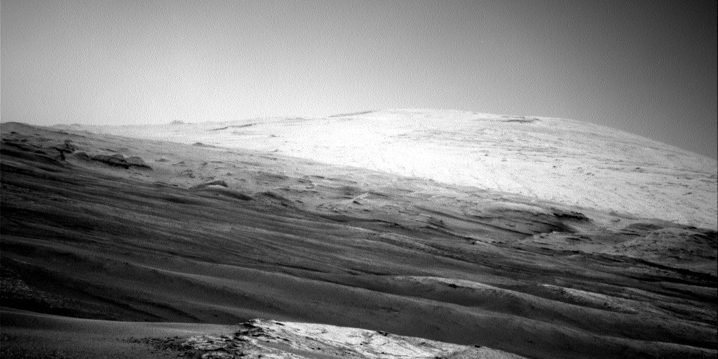
** Curiosity’s travels via Leonard David:

  • Curiosity Mars Rover: Eying Teal Ridge Outcrop – June.25.2019

    “Curiosity is still perched on top of Teal Ridge to investigate a fascinating outcrop that caps the ridge,” reports Kristen Bennett, a planetary geologist at the USGS in Flagstaff, Arizona.Scientists have been characterizing the ridge-capping material, but also devoting time to use the Sample Analysis at Mars (SAM) Instrument Suite to look for methane.

MAHLI-Sol-2444-June-22-2019
“Curiosity Mars Hand Lens Imager (MAHLI) image produced on Sol 2444, June 22, 2019. Credit: NASA/JPL-Caltech/MSSS.” Larger image
  • Curiosity Mars Rover: Ridge Work – June.20.2019

    NASA’s Curiosity Mars rover is now carrying out Sol 2442 duties, parked on Teal Ridge, in the midst of an extended contact science campaign.At this ridge location, new imagery from the robot shows crossbedding in a bedrock layer, as well as a contact between the bedrock outcrop and a rubbly layer below.

Curiosity Navcam - Sol-2442-June-20-2019
A view from Teal Ridge taken by Curiosity’s Navcam – Sol-2442-June-20-2019
“Curiosity Navcam Left B image taken on Sol 2439, June 17, 2019. Credit: NASA/JPL-Caltech.” Larger image.

** Bob Zimmerman reports on interesting Mars images taken from orbit:

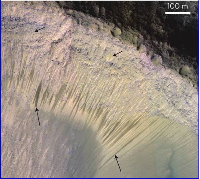
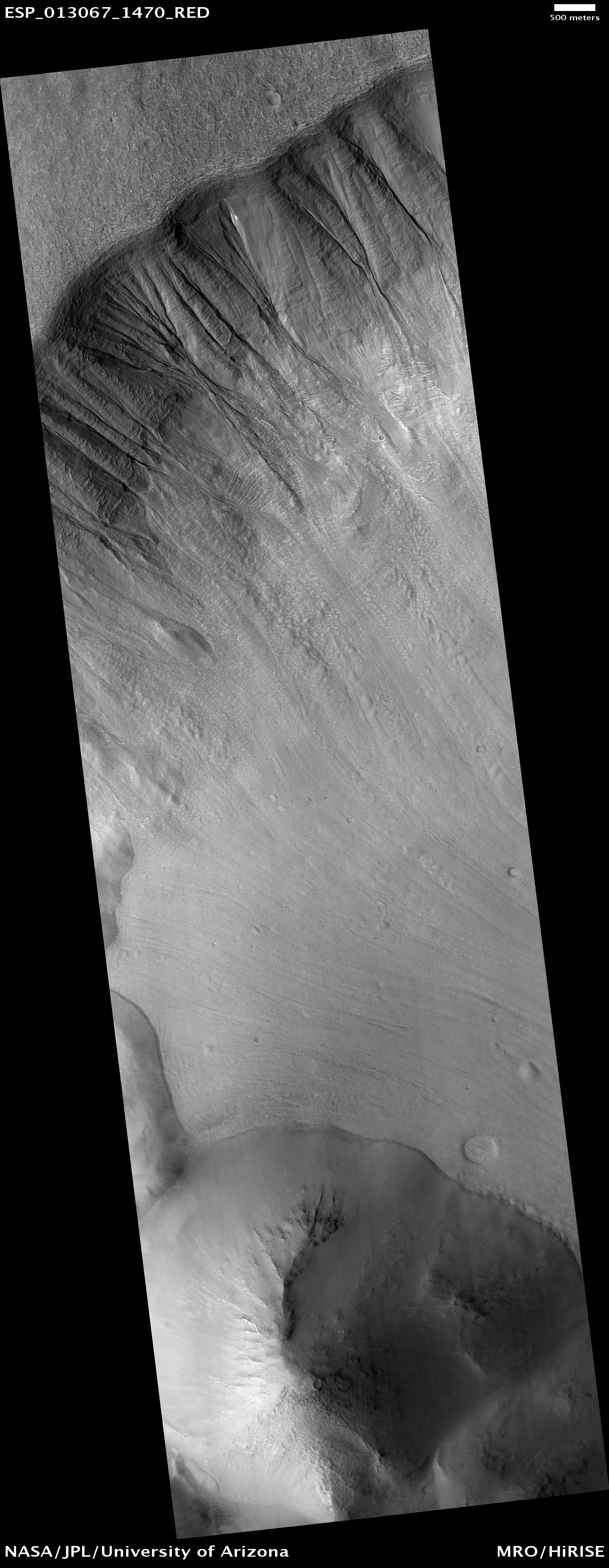
  • Strange Martian gullies – June.21.2019 – Bob finds the gullies in the image “Older Gullies and Channels” below fascinating –

    … because they appear to be some form of erosion drainage coming down both sides of a high ridge near the northern rim of this large apparently unnamed crater in the southern cratered highlands of Mars, to the west of Hellas Basin.On Earth my immediate explanation for this erosion would be a major monsoon-like storm, such as we get here in the southwest and call “gully-washers.” When a lot of water is quickly dumped onto a hill where there is not of vegetation to help bind the soil together, the water will quickly carve out gullies that looks almost exactly like these.

Older Gullies and Channels in Slopes of Softened Large Crater
Older Gullies and Channels in Slopes of Softened Large Crater – HiRISE

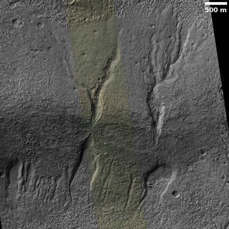
On Mars, who knows? It certainly wasn’t a monsoon thunderstorm that did this. And being in the Martian southern highlands it is unlikely it was from an ocean of any kind. Were there lakes here? Past research has found places where lakes might have existed on Mars, but these places are far north in the transitional zone into the northern lowlands.
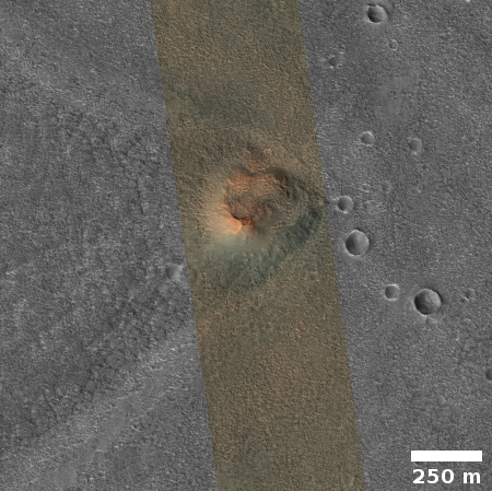
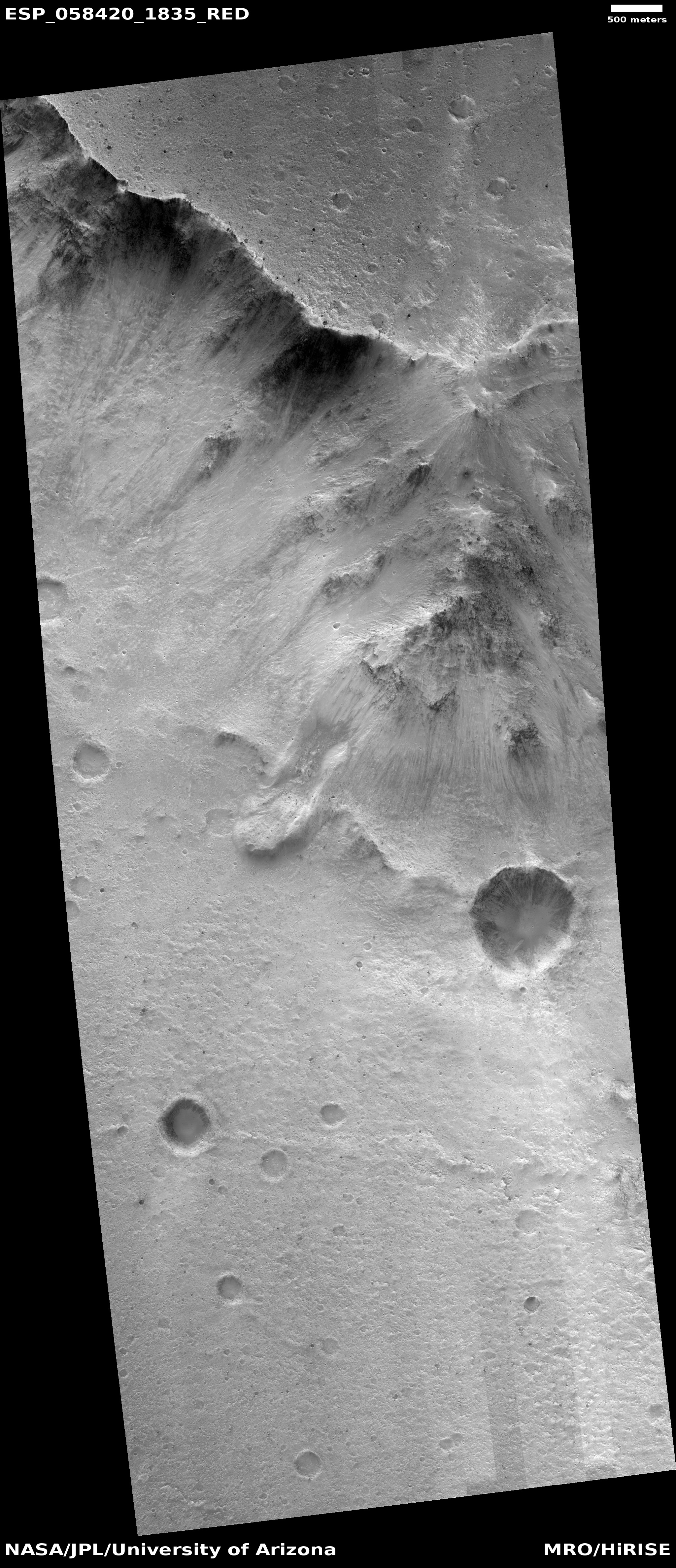
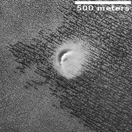
  • Mass wasting on Mars – June.19.2019Mass wasting is a term that geologists use to describe a specific kind of avalanche, where the material moves down slope suddenly in a single mass.The image [below], taken from the image archive of the high resolution camera on Mars Reconnaissance Orbiter (MRO) and cropped and reduced in resolution to post here, shows a dramatic example of this kind of avalanche. You can see two separate avalanches, each of which moved a significant blob of material down slope into the center of the crater floor.

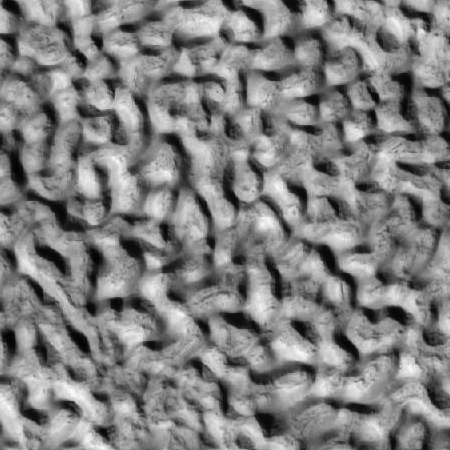
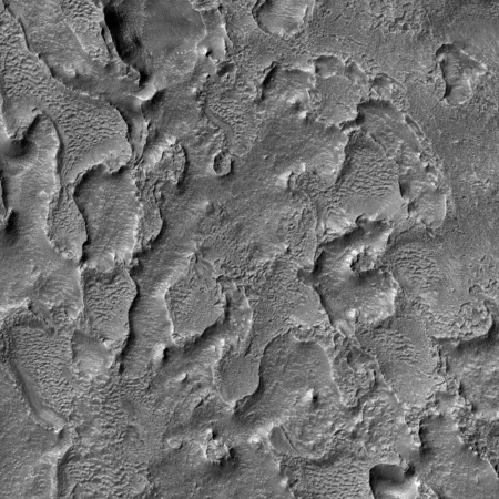
  • Wind and/or water erosion on the Martian northern lowlands – June.17.2019The picture [below], cropped and reduced in resolution to show here, was taken by the high resolution camera on Mars Reconnaissance Orbiter on April 21, 2019, and shows the erosion process produced by either wind or water as it flowed from the east to the west past one small mesa.It is almost certain that the erosion here was caused by wind, but as we don’t know when this happened, it could also be very old, and have occurred when this terrain was at the bottom of the theorized intermittent ocean that some believe once existed on these northern lowlands. The location itself, near the resurgences for Marineris Valles and the other drainages coming down from the giant volcanoes, might add weight to a water cause, except that the erosional flow went from east to west, and the resurgences were coming from the opposite direction, the west and the south.
Topographic Interactions in Vastitas Borealis
Topographic Interactions in Vastitas Borealis. HiRISE at U. of Arizona.

====

I Was a Teenage Space Reporter:
From Apollo 11 to Our Future in Space

Space sciences roundup – Apr.3.2019

A sampling of recent articles, videos, and images from space related science news:

** SpaceIL’s Beresheet prepares to enter lunar orbit on Thursday, April 4th. The vehicle fired its engine on Monday for 72 seconds to lengthen its long elliptical earth orbit. This will bring the spacecraft close enough to the Moon so that a brief firing of the engine there will put it into lunar orbit. On April 11, a final firing of the engine will send the vehicle down for a landing on the surface.

Photo of earth taken by Beresheet on March 1st from about 16,000 kilometers as the spacecraft made its last past by earth. The photo shows the Arab Peninsula and Southeast Africa.

If successful, this will be the first non-governmental spacecraft to go into orbit around another celestial object. And the first such to attempt a landing.

If the landing on Mare Serenitatis, in the northern hemisphere of the Moon, is successful, the craft will operate for about 2 days. The area is known for magnetic anomalies and the magnetometer device on the craft will measure the field strength during its descent and at the landing site.

The spacecraft also holds an array of mirrors provided by NASA for ground tracking and Deep Space Network support to aid in mission communication: NASA, Israel Space Agency Sign Agreement for Commercial Lunar Cooperation – NASA

See also:

** Japan’s Hayabusa2 soon to shoot a projectile into the Ryugu asteroid to learn about the characteristics of the surface material.

From Jason Davis:

The spacecraft is about to deploy an explosives-filled box that will detonate in space, fire a copper plate into Ryugu, and create a crater up to 10 meters wide. The moment of crater generation is set for 5 April at 02:36 UTC. …

… There’s a lot of uncertainty involved with SCI [Small Carry-on Impactor], which makes it a really interesting experiment. Scientists aren’t quite sure how big the crater will be. They can only aim SCI to a certain degree; the target spot has a margin of error of 200 meters. The width of the crater will depend on the type of material the impactor hits. Most models estimate a crater up to 10 meters wide, but there are a few surface types that could result in either a very small crater (if the impactor hits a particularly porous spot) or a crater even larger than 10 meters (if it hits a bunch of tiny, coarse pebbles). The crater depth is expected to be about a tenth of its diameter, which is actually a rule of thumb for simple, bowl-shaped craters anywhere in the solar system!

The target area is near Ryugu’s equator, about a quarter of the way around the asteroid east of the first sample collection site. That’s roughly 300 meters from MASCOT’s final resting place, so it’s not impossible that SCI could hit quite close to the now-dead lander. Since the Hayabusa2 team might also collect a sample from this artificial crater, they chose a spot geologically similar to the first touchdown site, allowing for an above-and-beneath-the-surface comparison. The location is also relatively free of hazards, which should help for a future touchdown.

Artist’s conception of the SCI experiment. The left panel shows the release of the SCI from the Hayabusa2 spacecraft. The right panel shows the DCAM3 camera  (silver cylinder) observing the explosion while Hayabusa2 is hides behind asteroid Ryugu to avoid the resulting debris.

** China’s station on the far side of the Moon re-awakens after surviving another 2 week long lunar night.

The rover was designed to last for three lunar days, but much like NASA missions that regularly outlive their initial mandates, Yutu 2’s mission may stretch on longer, the Chinese space agency hopes. (The current rover’s predecessor, Yutu, lost its roving ability on its second day on the moon.)

The China Lunar Exploration Program, which heads up the mission, has not provided any details about its scientific plans for the fourth day of Chang’e 4, which is focused on exploring the far side of the moon and how it differs from the near side. 

** Launch of India’s Chandrayaan-2 lunar lander delayed till May – Chandrayaan-2 mission deferred again, scheduled for May launch | India News – Times of India

Unlike the Chandrayaan-1 programme in 2008 that involved only orbiting around the moon, Chandrayaan-2 is a much complicated mission. It involves a soft-landing on the lunar surface and a rover that will move on the moon’s surface for 100 metre and analyse the soil content. Isro is, therefore, not taking any risk and taking time to fix all possible glitches as it wants a perfect landing.

Another reason for the postponement is that space agency wants to make use of the full lunar day (equal to 14 earth days). In January, the Isro chairman told TOI, “We want to land the rover at a time when it can use the full lunar day and do all scientific experiments. For that to happen, there is a launch window. If we miss the window, we have to defer the launch.

** SpaceFab commercial space telescope project awards observing time on the company’s soon-to-be-launched Waypoint space telescope to Dr. David Rubin of Univ. of Hawaii: SpaceFab.US Awards Space Telescope Time for Research – SpaceFab.US

Dr. Rubin’s program will use the Waypoint satellite’s EMCCD (Electron Multiplying Charge Coupled Device) camera to make rapid UV (ultraviolet) observations of newly discovered type Ia supernovae. Almost all UV light is absorbed by the Earth’s atmosphere, so only a telescope in the vacuum of space can make these types of measurements. The Waypoint satellite can be rapidly tasked to take priority observations within 90 minutes.

Dr. Rubin is currently a postdoctoral researcher at the Space Telescope Science Institute, but has accepted a faculty position at the University of Hawaii starting in August 2019.  His primary focus is on supernova cosmology, and is currently co-running a program to dramatically increase the number of distant SNe Ia to get substantially improved cosmological constraints.

The company will make money by leasing observation time on the orbital instrument to scientific and commercial users. The Waypoint Space Telescope is

a 21 centimeter mirror, launching as a co-payload on a SpaceX launch vehicle  in 2020. This commercial telescope will have an image intensified ultraviolet /visible 8 megapixel camera, and a 48MP main camera for visible and near-infrared imaging for astronomical and Earth observation purposes, available for use by customers around the world.  

The Waypoint telescope will also provide 150 band hyper-spectral camera for Earth observation at 3  meter resolution for use in scientific and commercial applications.  These applications include efficient farming, mineral and geological surveys, environmental studies,  climate change, disaster relief, oil spills, animal migrations, monitor urban growth and more.

SpaceFab’s Waypoint telescope design provides twice the resolution of other satellite telescopes of equivalent size and weight by using extending optics. The telescope is launched with a standard 12U cubesat form factor, then the secondary optics assembly is extended when in orbit. This doubles the telescope focal length while cutting the size, weight, and launch cost in half compared to conventional satellite telescopes with similar resolution.

Waypoint space telescope design rendering.

An interview from 2017 with Sean League, SpaceFab co-founder and Spacecraft Engineering Director:

** Dunes, Walnut Shells, Alien Impostors and Other Worlds: A Visit with Sarah Hörst | The Planetary Society

A very special, extended conversation with Johns Hopkins University planetary scientist Sarah Hörst is capped by a tour of her fascinating lab. That’s where Sarah and her team simulate decidedly un-Earthlike atmospheres and more. Emily Lakdawalla has returned from this year’s Lunar and Planetary Science Conference with news from around the solar system. Caffeine! It’s on Saturn’s moon Titan AND in the espresso made on the International Space Station! More about the latter in What’s Up.

** Exploring Ultima Thule: humanity’s next frontier – A SETI Institute panel discusses

… the key results of this successful flyby and the future of the mission, we invited Alan Stern, planetary scientist at Southwest Research Institute and the Principal Investigator of NASA’s New Horizons mission who will join us remotely via video-conferencing. Two Senior Research Scientists from our own SETI Institute who are part of the mission will participate in this discussion as well. Mark Showalter is a Fellow of the Institute who led the New Horizons risk assessment team before the flyby, and Ross Beyer, also a member of the New Horizons Geology and Geophysics team, who is helping to understand the 3D shape of MU69.

** A helicopter is ready to go to Mars in 2020 following successful tests in Martian level atmospheric pressure: NASA has been testing the helicopter that will head to Mars next year – MIT Technology Review

** A brief burst of Methane seen by Curiosity rover was also detected by the Mars Express spacecraft as it flew over the same area:  Mars Express matches methane spike measured by Curiosity – ESA

While spacecraft and telescopic observations from Earth have in general reported no or very low detections of methane, or measurements right at the limit of the instruments’ capabilities, a handful of spurious spikes, along with Curiosity’s reported seasonal variation at its location in Gale Crater, raise the exciting question of how it is being generated and destroyed in present times.

Now, for the first time, a strong signal measured by the Curiosity rover on 15 June 2013 is backed up by an independent observation by the Planetary Fourier Spectrometer (PFS) onboard Mars Express the next day, as the spacecraft flew over Gale Crater.

Methane is of particular interest because it is a short lived gas that could be a signature of a biological process. However, there are also geologic processes that could produce it and there are no methods yet for distinguishing the two possible origins of the gas: There Is Definitely Methane on Mars, Scientists Say. But Is It a Sign of Life? – Space.com

** Mars underground water ice on the move:

From Leonard David:

New research suggests deep groundwater on Mars could still be active and creating surface streams in some near-equatorial areas on the planet.

Once again, scientists point to the planet’s recurring slope lineae – RSL for short – that are akin to dried, short streams of water that appear on some crater walls.

Leonard David: “NASA Mars Reconnaissance Orbiter’s HiRISE image of recurring slope lineae in Melas Chasma, Valles Marineris. Arrows point out tops and bottoms of a few lineae.” Credit: NASA/JPL-Caltech/University of Arizona

** Recent analyses of Mars images by Bob Zimmerman:

** Undergrad detects 2 exoplanets in Kepler space telescope data using a deep-learning neural network program:

** The Weekly Space Hangout includes interviews and discussions of topics in the space sciences. Here is a sampling of recent shows:

====

Chasing New Horizons: Inside the Epic First Mission to Pluto

Space sciences roundup – Mar.20.2019

A sampling of recent articles, videos, and images about space related science news:

** Ultima Thule grows from a dot to a world in this time lapse of images captured by the New Horizons probe as it approached the Kuiper Belt object: Approach to Ultima Thule – New Horizons

Ultima Thule is providing a plethora of clues to the early formation stages of the solar system: A Prehistoric Puzzle in the Kuiper Belt | NASA

This strange shape is the biggest surprise, so far, of the flyby. “We’ve never seen anything like this anywhere in the solar system,” said New Horizons Principal Investigator Alan Stern, of the Southwest Research Institute, Boulder, Colorado. “It is sending the planetary science community back to the drawing board to understand how planetesimals – the building blocks of the planets – form.”

Because it is so well preserved, Ultima Thule is offering our clearest look back to the era of planetesimal accretion and the earliest stages of planetary formation. Apparently Ultima Thule’s two lobes once orbited each other, like many so-called binary worlds in the Kuiper Belt, until something brought them together in a “gentle” merger.

“This fits with general ideas of the beginning of our solar system,” said William McKinnon, a New Horizons co-investigator from Washington University in St. Louis. “Much of the orbital momentum of the Ultima Thule binary must have been drained away for them to come together like this. But we don’t know yet what processes were most important in making that happen.”

**Asteroid Bennu is spewing out dust as seen in the latest images from the OSIRIS-REx probe, which reached the near earth object last December: Bennu Particle Ejection Event – Jan. 19, 2019 – OSIRIS-REx Mission

“This view of asteroid Bennu ejecting particles from its surface on January 19 was created by combining two images taken by the NavCam 1 imager onboard NASA’s OSIRIS-REx spacecraft: a short exposure image (1.4 ms), which shows the asteroid clearly, and a long exposure image (5 sec), which shows the particles clearly. Other image processing techniques were also applied, such as cropping and adjusting the brightness and contrast of each layer. Date Taken: Jan. 19, 2019” – Credit: NASA/Goddard/University of Arizona/Lockheed Martin

This behavior was not expected: NASA Mission Reveals Asteroid Has Big Surprises | NASA

“The discovery of plumes is one of the biggest surprises of my scientific career,” said Dante Lauretta, OSIRIS-REx principal investigator at the University of Arizona, Tucson. “And the rugged terrain went against all of our predictions. Bennu is already surprising us, and our exciting journey there is just getting started.”

Shortly after the discovery of the particle plumes on Jan. 6, the mission science team increased the frequency of observations, and subsequently detected additional particle plumes during the following two months. Although many of the particles were ejected clear of Bennu, the team tracked some particles that orbited Bennu as satellites before returning to the asteroid’s surface.

The OSIRIS-REx team initially spotted the particle plumes in images while the spacecraft was orbiting Bennu at a distance of about one mile (1.61 kilometers). Following a safety assessment, the mission team concluded the particles did not pose a risk to the spacecraft. The team continues to analyze the particle plumes and their possible causes.

“The first three months of OSIRIS-REx’s up-close investigation of Bennu have reminded us what discovery is all about — surprises, quick thinking, and flexibility,” said Lori Glaze, acting director of the Planetary Science Division at NASA Headquarters in Washington. “We study asteroids like Bennu to learn about the origin of the solar system. OSIRIS-REx’s sample will help us answer some of the biggest questions about where we come from.”

The mission will go through several different phases of its investigation of the asteroid starting with the Baseball Diamond Phase:

The in-depth study of Bennu begins in earnest during Detailed Survey: Baseball Diamond Phase. OSIRIS-REx will make multiple passes around Bennu to produce the wide range of viewing angles necessary to fully observe the asteroid. The spacecraft will also use its OTES spectrometer to map the chemical composition of Bennu’s entire surface. Images obtained during this phase will be of high enough resolution to produce digital terrain maps and global image mosaics for proposed sample sites. Bennu’s terrain will be surveyed in bulk and sections will be classified as either “safe” or “unsafe,” with the results visualized on a hazard map.

The phase’s name comes from the early stage of mission design when the stations the spacecraft would traverse were arranged in the shape of a baseball diamond.  Although the mission design has since evolved, the original name for the phase remains.

In 2023 the spacecraft will return to earth with samples of the asteroid’s surface, some of which is seen in these detailed images: A Region of Bennu’s Northern Hemisphere Close Up | NASA

This trio of images acquired by NASA’s OSIRIS-REx spacecraft shows a wide shot and two close-ups of a region in asteroid Bennu’s northern hemisphere. The wide-angle image (left), obtained by the spacecraft’s MapCam camera, shows a 590-foot (180-meter) wide area with many rocks, including some large boulders, and a “pond” of regolith that is mostly devoid of large rocks. The two closer images, obtained by the high-resolution PolyCam camera, show details of areas in the MapCam image, specifically a 50-foot (15 meter) boulder (top) and the regolith pond (bottom). The PolyCam frames are 101 feet (31 meters) across and the boulder depicted is approximately the same size as a humpback whale.

The images were taken on February 25 while the spacecraft was in orbit around Bennu, approximately 1.1 miles (1.8 km) from the asteroid’s surface. The observation plan for this day provided for one MapCam and two PolyCam images every 10 minutes, allowing for this combination of context and detail of Bennu’s surface.

** Lunar sample containers unopened since Apollo astronauts filled them during EVAs on the surface will soon be examined by teams of researchers who will take advantage of modern instruments to attain better insights into what the materials say about the formation and subsequent development of the Moon: NASA Selects Teams to Study Untouched Moon Samples | NASA

NASA has selected nine teams to continue the science legacy of the Apollo missions by studying pieces of the Moon that have been carefully stored and untouched for nearly 50 years. A total of $8 million has been awarded to the teams.

“By studying these precious lunar samples for the first time, a new generation of scientists will help advance our understanding of our lunar neighbor and prepare for the next era of exploration of the Moon and beyond, “ said Thomas Zurbuchen, Associate Administrator for NASA’s Science Mission Directorate in Washington, DC. “This exploration will bring with it new and unique samples into the best labs right here on Earth.”

** Mars:

**** Opportunity rover’s last shot. While Opportunity has now gone quiet, it left an enormous legacy of data and images including a beautiful final parting panorama: Opportunity’s Parting Shot Was a Beautiful Panorama – NASA’s Mars Exploration Program

Opportunity’s final panorama with notations.

**** Huge caves on Mars appear more likely with the latest findings: New evidence for many large and extensive Martian cave systems | Behind The Black.

The second important implication of this finding, and the one that is possibly more important, is that this research suggests that there are many many many underground voids on Mars, formed by water, that could be found in many places. Some might be easily accessible. Some might require drilling into. In either case, they would provide ample locations for building habitable colonies.

And they would likely still have that water, now frozen into the underground ice table.

The possibilities are mind-boggling. They suggest that everyone studying Mars must rethink the surface features. The alienness of Mars means they might resemble Earth geology, but might have formed in ways we have not previously imagined. And the consequences of that alien formation might make future human colonization far easier.

****  Caves appear common on rocky worlds throughout our solar system: “The Planets Under Our Feet: Caves on Earth, Mars, and Beyond” –

Dr. Penelope Boston, NASA Ames Research Center New exploration indicates that caves may be more common on rocky and icy worlds in our Solar System than we have thought in the past. Caves below the Earth show us a very different planet than the familiar one we experience on the surface. Each dark cave system has its own micro-organisms and distinctive mineral and chemical properties. Dr. Boston takes us on a tour of the some of the most spectacular caves under the Earth and the unusual life-forms they harbor, and considers how the lessons they teach us can be applied to the exploration of the Solar System, especially the icy moons of the giant planets.

**** More Mars geology findings are highlighted by Bob Zimmerman who closely monitors the latest image releases from the orbiters:

The image shows numerous evidence of avalanches and erosion, both at its base and at its rim. None of these avalanches likely occurred during those catastrophic floods, but long afterward.

Signs of “landslides on the face of the mesa north of Hydraotes Chaos”. Mars Reconnaissance Orbiter HiRISE camera via Bob Zimmerman.

The top inset is shown to the left. Here very large sections of the the cliff face at the rim have broken off, dropping giant blocks downward. This material piles up to create an alluvial slope heading down to the floor of the canyon. On the upper cliff and on this slope the dark streaks indicate both past landslides as well as possible seeps of water coming out of the cliff face.

The bottom inset is shown next to the left. It focuses on the head of the largest landslide, and shows a flow at its base that resembles a gravitational collapse as shown in this science paper about Martian ground water.

You are staring at one of the unsolved mysteries on Mars. This surface texture of interconnected ridges and troughs, referred to as “brain terrain” is found throughout the mid-latitude regions of Mars. (This image is in Protonilus Mensae.)

This bizarrely textured terrain may be directly related to the water-ice that lies beneath the surface. One hypothesis is that when the buried water-ice sublimates (changes from a solid to a gas), it forms the troughs in the ice. The formation of these features might be an active process that is slowly occurring since HiRISE [MRO’s high resolution camera] has yet to detect significant changes in these terrains.

A section of a MRO HiRISE image showing a Mars region with an appearance named “Brain Terrain”. (Via Bob Zimmerman)

At today’s presentations at the 50th Lunar and Planetary Science Conference in Texas, scientists showed images and data [pdf] suggesting that many of the Martian gullies found on cliff faces are formed when the dust layer protecting underlying snow gets blown away and the exposed snow/ice then melts.

The image [below] was taken by the high resolution camera of Mars Reconnaissance Orbiter (MRO) in 2009, and has been cropped to post here. The white streaks are what they suggest is exposed ice/snow.

A section of a MRO HiRISE image that appears to show white streaks of water ice in a cliff gully.

** The locations of science spacecraft in our solar system are shown in this video from the Planetary Society:

Emily Lakdawalla takes us on a tour of the spacecraft currently exploring from within our solar system. All planets and spacecraft locations are shown at their location for April 1st, 2019.

====

Chasing New Horizons: Inside the Epic First Mission to Pluto

Space science roundup – Feb.21.2019

A sampling of recent articles, videos, and images related to space related sciences:

** Mars weather reportsDaily Mars weather reports are now available from the Insight lander, which has activated its temperature and wind sensors – InSight Is the Newest Mars Weather Service | NASA

This public tool includes stats on temperature, wind and air pressure recorded by InSight. Sunday’s weather was typical for the lander’s location during late northern winter: a high of 2 degrees Fahrenheit (-17 degrees Celsius) and low of -138 degrees Fahrenheit (-95 degrees Celsius), with a top wind speed of 37.8 mph (16.9 m/s) in a southwest direction. The tool was developed by NASA’s Jet Propulsion Laboratory in Pasadena, California, with partners at Cornell University and Spain’s Centro de Astrobiología. JPL leads the InSight mission.

The white east- and west-facing booms — called Temperature and Wind for InSight, or TWINS — on the deck of NASA’s InSight lander belong to its suite of weather sensors. Credits: NASA/JPL-Caltech. Full image and caption

Through a package of sensors called the Auxiliary Payload Subsystem (APSS), InSight will provide more around-the-clock weather information than any previous mission to the Martian surface. The lander records this data during each second of every sol (a Martian day) and sends it to Earth on a daily basis. The spacecraft is designed to continue that operation for at least the next two Earth years, allowing it to study seasonal changes as well.

The tool will be geeky fun for meteorologists while offering everyone who uses it a chance to be transported to another planet.

Today’s readings:

A similar weather report is available from the Curiosity rover: Rover Environmental Monitoring Station (REMS) – Mars Science Laboratory.

The Mars Reconnaissance Orbiter (MRO) provides a view of global Martian atmosphere conditions: MRO MARCI Weather Report – Malin Space Science Systems.

** The Mars 2020 rover is coming together at NASA JPL in preparation for launch next year:

Tour the Spacecraft Assembly Facility at NASA’s Jet Propulsion Laboratory and see the Mars 2020 mission under construction. Project System Engineer Jennifer Trosper explains the hardware being built and tested, including the rover, descent stage, cruise stage, back shell and heat shield. This NASA mission is preparing to launch to the Red Planet in 2020 and land in 2012. For more about Mars 2020, visit https://mars.nasa.gov/m2020

** Rovers on Mars and the Moon:  Bob Zimmerman gives an update on Curiosity as it slowly ascends Mt Sharp and on China’s Yutu-2 rover on the lunar surface: Rover update: February 20, 2019 | Behind The Black

The valley that Curiosity is presently traversing is dubbed “the clay unit” or “the clay-bearing unit” by the geologists, based on its make-up determined from orbital data. So far they have found this terrain to be “some of the best driving terrain we’ve encountered in Gale Crater, with just some occasional sandy patches in the lee of small ridges.” Initially they had problems finding any rocks or pebbles large enough for the instruments to use for gathering geological data. For the past week or so, however, they have stopped at “bright exposure of rock” where some bedrock was visible, giving them much better material to work with.

Click to see Curiosity’s track for past couple of years.

** Mars once had rivers flowing on its surface as shown by river beds seen from orbit. But up close images of the river beds show that it has been billions of years since water flowed over them: A river valley floor on Mars | Behind The Black

The floor of a canyon in Reull Vallis.

Here we see that the floor has been significantly eroded by later processes after the water disappeared. Later, wind action, which probably contributed to that erosion, also placed dust and dunes within the depressions here.

A lot of time has passed since that river flowed through Reull Valles. Or to put it another way, Mars has generally been a very dry place for a very long time. It might have considerable water at its poles as well hidden in an underground ice aquifer, but its surface is far drier than any desert on Earth, and has been for eons.

** Odd looking surface features on Mars are not uncommon. Here Bob examines an unusual pit that he spotted in an image of the south pole: Strange crescent-shaped pit near Martian south pole | Behind The Black

I found it in the February image release from the high resolution camera on Mars Reconnaissance Orbiter. I have merely cropped the full image to focus at full resolution on its primary feature, a region of stippled-like surface surrounding an area of black striping that in turn surrounds a crescent-shaped pit outlined by whiter material.

Why is there a pit here? Why is it crescent-shaped? Why is it surrounded by that whiter material? I could guess and say that the pit is a vent from which water vapor from the lower cap of water sprays out onto the upper cap of frozen carbon dioxide, staining it with white ice, but I am most likely wrong.

Moreover, what causes the black striping, as well as the stippled material surrounding it? The black stripes are probably related to a similar process that forms the spider formations found in the polar regions, except that these are not spiders. Why the parallel straight lines?

** The Chinese Chang’e 4 lander & rover on the far side of the Moon are currently in hibernation during the 2 week long lunar night. The Lunar Reconnaissance Orbiter has posted images of the pair taken during a pass over its location:

On 30 January LROC acquired a spectacular limb shot centered on the Chang’e 4 landing site, looking across the floor of Von Kármán crater. At the time, LRO was more than 200 kilometers from the landing site so Chang’e 4 was only a few pixels across and the rover was not discernable. The following day LRO was closer to the  site and again slewed (59° this time) to capture another view. This time the small Yutu-2 rover shows up (two pixels) just north of the lander. Also, shadows cast by the lander and rover are now visible.

“The Chang’e 4 rover is now visible to LROC! Just beyond the tip of the right arrow is the rover and the lander is to the right of the tip of the left arrow. The image appears blocky because it is enlarged 4x to make it easier to see the two vehicles. North is to the upper right, LROC NAC M1303570617LR [NASA/GSFC/Arizona State University].”

The official Chinese lunar exploration website doesn’t appear to offer an English version but your can always use the Google translation.

** Fly around Jupiter – Here is a cool time-lapse of images from the Juno probe as it made its 17th close pass above Jupiter’s clouds: ‘Juno’s Perijove-17 Jupiter Flyby, Reconstructed in 125-Fold Time-Lapse’ | JunoCam : Processing | Mission Juno

Via Movie of Juno’s December 2018 Jupiter fly-by | Behind The Black.

** A Neptune moon is a chip off the old Proteus moon according to a new report based on Hubble telescope imaging: Tiny Neptune Moon Spotted by Hubble May Have Broken from Larger Moon | NASA

Astronomers call it “the moon that shouldn’t be there.”

After several years of analysis, a team of planetary scientists using NASA’s Hubble Space Telescope has at last come up with an explanation for a mysterious moon around Neptune that they discovered with Hubble in 2013.

The tiny moon, named Hippocamp, is unusually close to a much larger Neptunian moon called Proteus. Normally, a moon like Proteus should have gravitationally swept aside or swallowed the smaller moon while clearing out its orbital path.

So why does the tiny moon exist? Hippocamp is likely a chipped-off piece of the larger moon that resulted from a collision with a comet billions of years ago. The diminutive moon, only 20 miles (about 34 kilometers) across, is 1/1000th the mass of Proteus (which is 260 miles [about 418 kilometers] across).

** The Moon receives a constant shower of solar protons, which can interact with oxygen in surface rocks with oxygen-bearing molecules to produce hydroxyl (OH), which needs just one more proton to become water (H2O):  NASA Finds Moon Could Be a Chemical Factory for Water | NASA

When a stream of charged particles known as the solar wind careens onto the Moon’s surface at 450 kilometers per second (or nearly 1 million miles per hour), they enrich the Moon’s surface in ingredients that could make water, NASA scientists have found.

Using a computer program, scientists simulated the chemistry that unfolds when the solar wind pelts the Moon’s surface. As the Sun streams protons to the Moon, they found, those particles interact with electrons in the lunar surface, making hydrogen (H) atoms. These atoms then migrate through the surface and latch onto the abundant oxygen (O) atoms bound in the silica (SiO2) and other oxygen-bearing molecules that make up the lunar soil, or regolith. Together, hydrogen and oxygen make the molecule hydroxyl (OH), a component of water, or H2O.

“We think of water as this special, magical compound,” said William M. Farrell, a plasma physicist at NASA’s Goddard Space Flight Center in Greenbelt, Maryland, who helped develop the simulation. “But here’s what’s amazing: every rock has the potential to make water, especially after being irradiated by the solar wind.”

This has implications for lunar settlers:

A key ramification of the result, [NASA Goddard plasma physicist  William M. Farrell] said, is that every exposed body of silica in space — from the Moon down to a small dust grain — has the potential to create hydroxyl and thus become a chemical factory for water.

** Dark matters – On a recent episode of The Space Show (Fri, 02/15/2019)Dr. William Dawson of Lawrence Livermore National Laboratory (LLNL) discussed “dark matter, dark energy, physics research, black holes, research goals and legacy, gravitational waves, gravitational lensing and much more”.

====

Chasing New Horizons: Inside the Epic First Mission to Pluto

The Opportunity Rover mission declared over but other missions on Mars continue

After several months of futile efforts to contact Opportunity, which went silent last year during a dust storm that covered most of Mars, NASA today officially declared the end of the rover’s mission:

This video gives a brief review of Opportunity’s 15 years of exploration:

Opportunity left a long trail of accomplishments behind it: Look Back at Opportunity’s Record-Setting Mission – NASA

In this image from 2010, Opportunity used its navigation camera for this northward view of tracks the rover left on a drive from one energy-favorable position on a sand ripple to another. The rover team called this strategy “hopping from lily pad to lily pad.”

The Opportunity rover stopped communicating with Earth when a severe Mars-wide dust storm blanketed its location in June 2018. After more than a thousand commands to restore contact, engineers in the Space Flight Operations Facility at NASA’s Jet Propulsion Laboratory (JPL) made their last attempt to revive Opportunity Tuesday, to no avail. The solar-powered rover’s final communication was received June 10.

Designed to last just 90 Martian days and travel 1,100 yards (1,000 meters), Opportunity vastly surpassed all expectations in its endurance, scientific value and longevity. In addition to exceeding its life expectancy by 60 times, the rover traveled more than 28 miles (45 kilometers) by the time it reached its most appropriate final resting spot on Mars – Perseverance Valley.

The final transmission, sent via the 70-meter Mars Station antenna at NASA’s Goldstone Deep Space Complex in California, ended a multifaceted, eight-month recovery strategy in an attempt to compel the rover to communicate.

===

Meanwhile, activities of the other missions on Mars continue. The InSight lander in December deployed the seismometer and this week placed the heat probe onto the surface:

From the NASA JPL article:

NASA’s InSight lander has placed its second instrument on the Martian surface. New images confirm that the Heat Flow and Physical Properties Package, or HP3, was successfully deployed on Feb. 12 about 3 feet (1 meter) from InSight’s seismometer, which the lander recently covered with a protective shield. HP3 measures heat moving through Mars’ subsurface and can help scientists figure out how much energy it takes to build a rocky world.

Equipped with a self-hammering spike, mole, the instrument will burrow up to 16 feet (5 meters) below the surface, deeper than any previous mission to the Red Planet. For comparison, NASA’s Viking 1 lander scooped 8.6 inches (22 centimeters) down. The agency’s Phoenix lander, a cousin of InSight, scooped 7 inches (18 centimeters) down.

“We’re looking forward to breaking some records on Mars,” said HP3 Principal Investigator Tilman Spohn of the German Aerospace Center (DLR), which provided the heat probe for the InSight mission. “Within a few days, we’ll finally break ground using a part of our instrument we call the mole.”

NASA’s InSight Prepares to Take Mars’ Temperature. NASA’s InSight lander set its heat probe, called the Heat and Physical Properties Package (HP3), on the Martian surface on Feb. 12. Credit: NASA/JPL-Caltech/DLR. › Full image and caption

===

Check out a selection of recent images of Mars from the Curiosity Rover: Curiosity Mars Rover: Scenic Shots – LeonardDavid.com

Curiosity Mastcam Left Sol 2313 February 7, 2019
Credit: NASA/JPL-Caltech/MSSS

====

Chasing New Horizons: Inside the Epic First Mission to Pluto