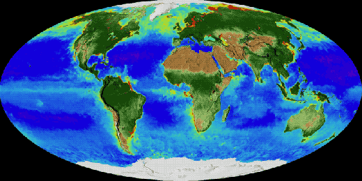
This time lapse GIF shows earth’s plant life cycling over 20 years as seen by NASA and NOAA satellite earth observation imagery:
From space, satellites can see Earth breathe. A new NASA visualization shows 20 years of continuous observations of plant life on land and at the ocean’s surface, from September 1997 to September. 2017. On land, vegetation appears on a scale from brown (low vegetation) to dark green (lots of vegetation); at the ocean surface, phytoplankton are indicated on a scale from purple (low) to yellow (high). This visualization was created with data from satellites including SeaWiFS, and instruments including the NASA/NOAA Visible Infrared Imaging Radiometer Suite and the Moderate Resolution Imaging Spectroradiometer. Credits: NASA
A United Launch Alliance Delta II rocket launched a new NOAA JPSS-1 weather satellite on Saturday morning from Vandenberg AFB in California. Here are videos of the launch and of the satellite separation from the upper stage:
Fires broke out quickly this past weekend in northern California. Sixty mile an hour winds did nothing to help either quell or stop the runaway fires from jumping fire lines and decimating whole neighborhoods. Dry, hot conditions which have been problematic for much of the west coast this summer erupted into flames after a series of lightning strikes. October is always a difficult time in California for wildfires, but this year, the wildfire eruptions seem extreme even to the most seasoned Californian. The deadly combination of lightning, winds, and hot weather which dries the landscape into tinder is all it takes to set off a wildfire that will consume thousands and thousands of acres in just a few short hours.
Fifteen fires ignited late Sunday evening, remained mostly uncontained, and are likely to continue spreading because of heat, low humidity and wind with many of these fires located in Sonoma Valley and Napa Valley, heart of California’s wine country. Despite the massive number of firefighters deployed to fight the flames, most fires remain 0% contained at present. Too many other factors are in play that make containment difficult including high winds, dry conditions, and low humidity.
NASA’s Aqua satellite collected this natural-color image with the Moderate Resolution Imaging Spectroradiometer, MODIS, instrument on October 09, 2017. Actively burning areas (hot spots), detected by MODIS’s thermal bands, are outlined in red. Each hot spot is an area where the thermal detectors on the MODIS instrument recognized temperatures higher than background. When accompanied by plumes of smoke, as in this image, such hot spots are diagnostic for fire.NASA image courtesy Jeff Schmaltz LANCE/EOSDIS MODIS Rapid Response Team, GSFC. Caption by Lynn Jenner
FireSat is a project started at NASA JPL to develop a constellation of satellites with sensors specialized at spotting wildfires. The goal is to detect and report a wildfire anywhere in the world within 15 minutes of its starting.
The FireSat sensors would be able to detect fires that are at least 35 to 50 feet (10 to 15 meters) wide, within an average of 15 minutes from the time they begin. Within three minutes of detecting a fire from orbit, FireSat would notify emergency responders in the area of the fire, improving support for time-critical response decisions.
The sensors and their associated products for data analysis would also be able to locate explosions, oil spills and other dangerous events involving high heat around the globe.
An announcement from the CosmoQuest public participation in space exploration initiative:
Public Invited to Test New Tool to Study Earth using Photos
Taken by International Space Station Astronauts
A phenomenal view – the world as seen by NASA astronaut Karen Nyberg from the Cupola of the International Space Station.
CosmoQuest’s Image Detective, a NASA-funded citizen science project, invites the public to identify Earth features in photographs taken by astronauts from the International Space Station (ISS). Citizen scientists are asked to help identify geographic features (natural or human-made) in astronaut photographs and then determine the location on Earth where the photo is centered. CosmoQuest is led by principal investigator Dr. Pamela L. Gay from the Astronomical Society of the Pacific (ASP).
“The astronauts’ photos of Earth are visually stunning, but more than that, they can be used to study our changing Earth,” says Dr. Gay, the Director of Technology and Citizen Science at the ASP. “From erupting volcanoes, to seasonal flooding, these images document the gradual changes that happen to our landscape. The trick is, we need to make these images searchable, and that means taking the time to sort through, analyze, and label (add metadata) the unidentified images within the database of 1.5 million plus photos.”
Originally developed by NASA Johnson Space Center (JSC) science experts within the JSC Astromaterials Research and Exploration Science (ARES) Division, Image Detective’s upgrade provides new and improved options for citizen scientists to help enhance NASA’s growing online database of astronaut imagery, also referred to as Crew Earth Observations (CEO) imagery.
Algerian desert from the ISS
Image Detective lets anyone with an Internet connection advance the usefulness of NASA’s vast catalogue of astronaut imagery. Since construction began in 2000, more than 200 people from 18 nations have visited the International Space Station (ISS). Orbiting just 250 miles above the Earth, this platform provides astronaut photographers an amazing platform for imaging our planet. As part of their day-to-day work on the ISS, astronauts are asked by the ESRS team at Johnson Space Center to take numerous photos of our planet Earth’s land surface, oceans, and atmosphere, including impressive auroral displays. Crews also take images of other solar system bodies, such as the Moon, planets, and stars. These images now need carefully labeled.
Image Detective spreads the significant work necessary to label all of the images out to citizen scientists across the world. “This is a unique, powerful, and beautiful image data set that has already yielded excellent research science. But the data set needs the many eyes and minds of citizen scientists to reach its full potential as a publicly available, searchable catalog,” said Dr. Jennifer Grier, a Senior Scientist and Senior Education and Communication Specialist at Planetary Science Institute (PSI) and CosmoQuest’s lead support scientist. “With the additions that citizen scientists as detectives can make, professional research scientists will be able to conduct more research into our changing world, and do so much more effectively.”
Your efforts can enhance NASA’s database of images taken by International Space Station Astronauts!
These efforts are supported by NASA under cooperative agreement award number NNX17AD20A. Any opinions, findings, and conclusions or recommendations expressed are those of this project and do not necessarily reflect the views of the National Aeronautics and Space Administration (NASA). Image Detective was produced through a collaboration of the Astronomical Society of the Pacific, the Astromaterials Research and Exploration Science (ARES) Division at the NASA Johnson Space Center, the Planetary Science Institute, Youngstown State University, and Southern Illinois University Edwardsville. NASA’s Gateway to Astronaut Photography of Earth (GAPE), the official online database of more than 1.5 million astronaut images, is curated by the Earth Science and Remote Sensing (ESRS) Unit, within the ARES Division at JSC. Photos used in Image Detective are courtesy of The Earth Science and Remote Sensing Unit and NASA Johnson Space Center. NASA’s official online database of astronaut imagery is available at: https://eol.jsc.nasa.gov.
The Astronomical Society of the Pacific, established in 1889, is a 501(c)3 nonprofit organization whose mission is to use astronomy to increase the understanding and appreciation of science and to advance science and science literacy. The ASP connects scientists, educators, amateur astronomers and the public together to learn about astronomical research, improve astronomy education, and share resources that engage learners of all kinds in the excitement and adventure of scientific discovery. In addition to CosmoQuest, current ASP programs and initiatives support college faculty, K-12 science teachers, amateur astronomy clubs, science museums, libraries, park rangers, and girl scouts to name a few.
Early Sunday morning, United Launch Alliance sent the US spysat NROL-42 into orbit with an Atlas V rocket blasting off from Vandenberg AFB in California. Here is a nice photo taken during the launch by Anthony Galván III:
Atlas V launch from Vandenberg AFB, California, 9/23/17 @22:55 hr. NROL-42 mission Image made from Goleta, California, 50 miles SE of the launch site.
Here is a ULA video with highlights of the preparations for the mission and of the launch: